


Published
Development of Tropical Lowland Peat Forest Phasic Community Zonations in the Kota Samarahan-Asajaya area, West Sarawak, Malaysia
DOI:
https://doi.org/10.15446/esrj.v20n1.53670Keywords:
Lowland peat swamp, Phasic community, Mangrove swamp, Riparian environment, Pollen diagram, Vegetation Succession (en)Logging observations of auger profiles (Tarmizi, 2014) indicate a vertical, downwards, general decrease of peat humification levels with depth in a tropical lowland peat forest in the Kota Samarahan-Asajaya area in the region of West Sarawak (Malaysia). Based on pollen analyses and field observations, the studied peat profiles can be interpreted as part of a progradation deltaic succession. Continued regression of sea levels, gave rise to the development of peat in a transitional mangrove to floodplain/floodbasin environment, followed by a shallow, topogenic peat depositional environment with riparian influence at approximately 2420 ± 30 years B.P. (until present time). The inferred peat vegetational succession reached Phasic Community I at approximately 2380 ± 30 years B.P. and followed by Phasic Community II at approximately 1780 ± 30 years B.P., towards the upper part of the present, ombrogenic, peat profile. Observations of the presence of large, hollow, Shorea type trees, supports that successive vegetational zonation of the tropical lowland peat dome may have reached Phasic Community II. Some pollen types were found that are also known to occur in the inferred vegetational zonation of Phasic Community III and IV or higher. Pollen analyses indicate that estuarine and deltaic, brackish to saline water influence may have gradually ceased at approximately 0.5 m below the lithological boundary between peat and underlying soil (floodplain deposit) in the tropical lowland peat basin.
https://doi.org/10.15446/esrj.v20n1.53670
Development of Tropical Lowland Peat Forest Phasic Community Zonations in the Kota Samarahan-Asajaya area, West Sarawak, Malaysia
Mohamad Tarmizi Mohamad Zulkifley1, Ng Tham Fatt1, Zainey Konjing2, Muhammad Aqeel Ashraf3,4*
1 Department of Geology, Faculty of Science, University of Malaya, Kuala Lumpur, Malaysia
2 Biostratex Sendirian Berhad, Batu Caves, Gombak, Malaysia.
3 Department of Environmental Science and Engineering, School of Environmental Studies, China University of Geosciences, 430074 Wuhan, P. R. China
4 Faculty of Science & Natural Resources, University Malaysia Sabah88400 Kota Kinabalu, Sabah, Malaysia.
* Corresponding authors: Muhammad Aqeel Ashraf- Faculty of Science & Natural Resources University Malaysia Sabah, 88400, Kota Kinabalu, Sabah. (ashraf@ums.edu.my)
Record
Manuscript received: 20/10/2015 Accepted for publication: 12/02/2016
How to cite item
Mohamad, M. T., Fatt, N. T., & Ashraf, M. A. Development of Tropical Lowland Peat Forest Phasic Community Zonations in the Kota Samarahan-Asajaya area, West Sarawak, Malaysia. Earth Sciences Research Journal, (20)1, O1-O10. doi: https://doi.org/10.15446/esrj.v20n1.53670
ABSTRACT
Logging observations of auger profiles (Tarmizi, 2014) indicate a vertical, downwards, general decrease of peat humification levels with depth in a tropical lowland peat forest in the Kota Samarahan-Asajaya área in the región of West Sarawak (Malaysia). Based on pollen analyses and field observations, the studied peat profiles can be interpreted as part of a progradation deltaic succession. Continued regression of sea levels, gave rise to the development of peat in a transitional mangrove to floodplain/floodbasin environment, followed by a shallow, topogenic peat depositional environment with riparian influence at approximately 2420 ± 30 years B.P. (until present time). The inferred peat vegetational succession reached Phasic Community I at approximately 2380 ± 30 years B.P. and followed by Phasic Community II at approximately 1780 ± 30 years B.P., towards the upper part of the present, ombrogenic, peat profile. Observations of the presence of large, hollow, Shorea type trees, supports that successive vegetational zonation of the tropical lowland peat dome may have reached Phasic Community II. Some pollen types were found that are also known to occur in the inferred vegetational zonation of Phasic Community III and IV or higher. Pollen analyses indicates that estuarine and deltaic, brackish to saline water influence may have gradually ceased at approximately 0.5 m below the lithological boundary between peat and underlying soil (floodplain deposit) in the tropical lowland peat basin.
Keywords: Lowland peat swamp, Phasic community, Mangrove swamp, Riparian environment, Pollen diagram, Vegetation Succession.
1. Introduction
Organic materials only accumulate to form peat under certain conditions, whereby it is essential that the production of biomass (organic materials) be greater than its chemical breakdown to form peat (Andriesse, 1988). Anaerobic, muddy conditions, which prevent the microbiological activity needed for the chemical breakdown of organic materials, are assumed to be largely responsible for the accumulation of partly decomposed biomass/organic matter in the form of peat. The anaerobic conditions are created by a particular hydro-topography whether marsh, swamp, bog or mire. Properties of such hydro-topographic units depend on many environmental factors, including climate, landform, local geology and hydrology (Andriesse, 1988).
The definition of peat also refers to the net accumulation of purely one hundred percent organic matter and the difference between soil and organic or vegetative accumulation varies (Murtedza et al., 2002) probably due to varying definitions from the different academic fields associated with the practical study of peat and its' properties (agriculture, botany, geology and engineering, for instance). 'Peat' has been alternately referred to as 'organic soils' and Histosols. Peat is referred to as organic soils by mass composition (Murtedza et al., 2002), i.e. soils that contain at least 65% organic matter or conversely, less than 35% mineral content. The Soil Division of Sarawak (Malaysia) has adopted a definition for organic soil that is based on profile partition, i.e. soils that have 50 cm or more organic soil matter within 100 cm or more than twice that of mineral soil materials overlying bedrock within 50 cm (Murtedza et al., 2002).
On the other hand, the United States Department of Agriculture (USDA) has defined soil types as organic soils (or Histosols) if more than half of the upper 80 cm of the soil is organic or if organic soil material of any thickness rests on rock or fragmental material having interstices filled with organic materials (United States Department of Agriculture, 1998; Murtedza et al., 2002). Peats, as we now know, are formed by the limited decomposition and hence, the accumulation of organic soil materials and these organic materials can further consist of undecomposed, partially decomposed and highly decomposed plant remains. Tropical lowland peats usually have undecomposed and partly decomposed branches, logs or twigs. Tropical lowland peats form a fragile ecosystem because of its' domed shape and is almost purely organic (Paramananthan, 2011).
2. Origin and characteristics of peat deposits
The paludal deposits of Sarawak occur in large basin swamps and in small interior valleys that have developed in mostly near coastal areas in relatively recent times (Murtedza et al., 2002).14C dating from Baram in northern Sarawak indicates that the sea was at the inland margin of the peat swamp about 5400 years ago (Wilford, 1960; Murtedza et al., 2002). Peat basin swamps are dome-shaped with 'ombrogenous peat' occupying the central portion of the peat dome (Murtedza et al., 2002; Tie, 1990). 'Ombrogenous peat' or ombrogenic peats (Paramananthan, 2011), comprises mainly of broken tree trunks, branches, leaves, roots and fruits (Yogeswaran, 1995; Huat, 2004; Anderson and Muller, 1975, Anderson, 1976) and are relatively mineral or ash free. However, the marginal peats surrounding the base and along fringes or margins of the peat dome and lower bank of streams draining the peat swamps are dominated by 'clayey or topogenic peat', which consists of mainly slightly to moderately decomposed plant matter and fine clastic mineral-sediments (moderate to high ash content).
3. Description of site studied
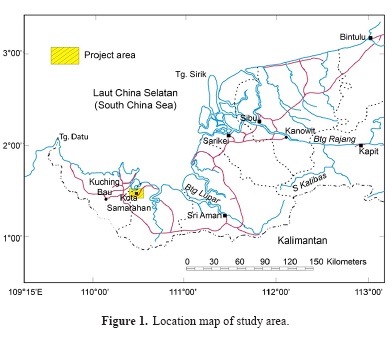
The study area covers approximately 25 km2, is located between longitudes 01º 26' 30''N and 01º 29'46''N (north and south of Sungai Tuang) and latitudes 110º 27'44''E and 110º 30'58''E (east and west of Batang Samarahan). It is located about 30 km from Kuching City and is accessible by sealed road. Within the study area (Figure 1), accessibility is possible using gravel, bund roads or sealed roads.
Physiography-topography, drainage, climate and vegetation
The topography of the Kota Samarahan-Asajaya area is flat and low-lying with isolated hills standing out of the floodplains of the Batang Samarahan and Sungai Tuang rivers. The general elevation of the flood basin is low and seldom higher than 5 m above sea level. The majority of these areas are prone to high tide flooding except few localities on the natural levees along rivers and man-made bunds.
The major rivers draining the study area into the South China Sea are the Batang Samarahan and its distributary, Sungai Tuang. The meandering Batang Samarahan flows in a northerly direction while the Sungai Tuang flows eastward to join the Batang Samarahan.
The area experiences an equatorial climate which is characterized by hot and humid conditions with a drier period during the middle of the year and high rainfalls at the end of the year.
4. Objective of study
The initial purpose of this study was to identify, classify and map the distribution and natural occurrence of peat deposits in the Kota Samarahan-Asajaya study area. A further objective was to determine the depth and thickness of peat encountered in the project area. The stratigraphy of a tropical lowland peat swamp and some of its related palynological characteristics were studied using samples collected from auger holes. The palynological investigation was performed to identify the peat swamp phasic communities' vegetation succession that had occurred from basal clay to present-day tropical lowland peat swamp forest based on pollen analyses of augered core samples. Also, this study aims to determine the initial age of peat deposition by 14C dating method.
5. Materials and Methods
Field methods
Augering was done using hand augers. Augered holes and sampling points were located using a Garmin GPS device (models GPS 76 and GPSmap 76CSx). Hand augered core samples were extracted, photographed and logged in the field. Peat classification was carried out on a scale of H1 to H10 in the field (Mohamad Tarmizi, 2014) using the von Post classification method (Engineering Geology Working Group, 2007; Von Post, 1922).
Peat sampler
The peat or Russian-type sampler was mainly used for peat sampling. It consists of an anchored fin and a movable sampling chamber. Samples collected using the peat sampler is not disturbed compared to those collected with the gouge auger (Guts auger). This is because the core sample remains enclosed within the sampling chamber throughout the process of sampling.
Field Description
Peat and organic soils
For field description, slightly organic silts or clays will appear as fine-grained inorganic soils, probably black or dark brown in colour, with an organic odour and possibly some visible organic remains. Peat, on the other hand, may well appear to be completely organic, contains many recognizable plants remains, have a low density and also being black or dark brown in colour. The peat material was described using the Von Post Squeeze test and results were provided according to the Von Post Degree of Humification with values between H1 and H10.
Soft soils classification and description
In the field, the cores were logged and described by visual observation and feel . The samples were described according to the Malaysian Soil Classification System for Engineering Purposes and Field Identification (Engineering Geology Working Group, 2007; Jarret, 1995; Bujang, 2004) which includes the factors of organic content and degree of humification for classification of peat. Soils that have organic content from 3 to 20% are termed Slightly Organic Soils, and soils with organic content in the range of 20 to 75% are classified as Organic soils. Finally, peats have more than 75% organic content. Fibric or fibrous peats (Ptf) have a humification range of H1 to H3 whereas hemic or moderately decomposed peats (Pth) have a range of H4 to H6. Sapric or amorphous peats range from H7 to H10 on the humification scale (Jarret, 1995; Bujang, 2004).
General geology
Soft, quaternary sediments underlie the study area. Two sedimentary facies observed to be exposed in the study area are the peat (paludal) deposits and floodplain deposits. From logging observations and pollen analyses, these two facies were observed and concluded to be deposited over the estuarine/deltaic sediments (Mohamad Tarmizi, 2014 and Mohamad Tarmizi et al., 2013(a), 2013(b) and 2013(c)).
Peat (Paludal) deposits
The term paludal deposits has been introduced to define a Holocene unit mainly made up of peat (Lam, 1989). Peat covers a small portion of the western part of the study area (also referred here as 'Plaie area'). The thickness of the peat in the western part/Plaie area ranges from 0.2 to 2.0 m.
The types of peat mapped and encountered in the study area are (a) topogenous peat: also known as clayey peat, composed of plant remains and clastic sediments (with ash content) and formed in topographic depressions by plants that extracted nutrients from the mineral subsoil. Topogenous peat is influenced by flood waters which supply the mineral components (mainly clays and silts). (b) Ombrogenous peat: plant remains formed by plants growing solely on nutrient cycled through vegetation and peat (no mineral subsoil or ash content) and is fed by rain water only. The type of peat produced is composed of plant remains without any clastic sediments from the mineral subsoil. It is usually formed beyond the flood levels and away from mineral deposition by flooding rivers.
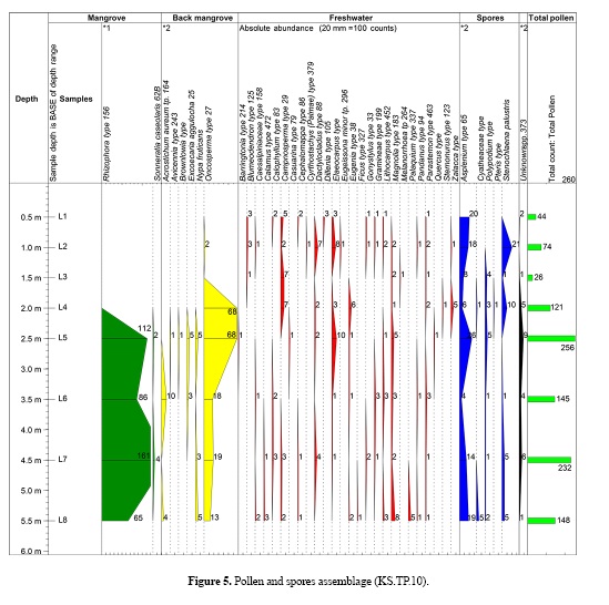
The topogenous peat is composed of slightly to moderately decomposed plant matters. Topogenous peat with a humification range of H3 to H8 on the von Post Humification scale was augered, logged and classified at the peat forest, in the Plaie area, on the western part of the study area (Figure 5). Ombrogenous peat is characterized by a high water content, an extremely low bulk density, a relatively higher decomposition rate and a relatively lower pH, and is composed of mainly loose trunks, branches, roots, fruits and leaves (Paramananthan, 2011). Ombrogenous peat encountered in the study area is moderate to highly decomposed and ranges from H4 (hemic) to H7 (sapric) on the von Post Scale of Humification. The Munsell colour value is 7.5YR 2.5/2 (very dark brown) depending on the degree of humification.
Peat in the western peat forest of study area (Plaie area)
Peat in the Plaie area is composed of slightly to moderately decomposed plant material ranging from H4 to H8 on the von Post Degree of Humification scale. The peat that was encountered vertically at location KS.TP.10 can be classified as hemic to sapric, hemic and fibric to hemic peat. The thickness of the peat layers from the margin (KS.TP.02) towards the basin centre (KS.TP.10) ranges from 0.2 to 2.3-m thick, getting thicker westwards. The peat encountered at locations KS.TP.09 and KS.TP.10 vertically has a dark brown to very dark brown colour ranging from 7.5 YR 3/3 and 7.5 YR 3/2 (dark brown) to 7.5 YR 2.5/2 (very dark brown) according to the Munsell Soil Colour Chart (Table 1). The groundwater levels in the western part of Kota Samarahan (Plaie) peat area are approximately 0.3 to 0.5-m below ground surface (Mohamad Tarmizi, 2014) at augered locations KS.TP.09 and KS.TP.10 respectively (Figure 2).

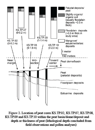
Field identification and classification (von Post) of the top to the bottom peat layer of the tropical lowland peat dome shows that there is a vertical variation of peat humification levels (von Post) with every 0.5-m interval of depth in the form of dominantly occurring hemic to sapric (H6 to H7), hemic (H5 to H6), hemic (H4 to H6) and fibric to hemic (H3 to H5) humification levels, respectively, at auger hole location KS.TP.10 , and sapric (H7 to H8), hemic to sapric (H6 to H7) and hemic (H5 to H6) humification levels, respectively, at auger location KS.TP.09 , with both profiles indicating a vertical decrease of peat humification levels with peat depth.
Floodplain deposits
The exposed floodplain deposits cover the northern, eastern and southern parts of the study area, including the cross river Asajaya areas clockwise from Kg. Sui, Kg. Tanjung Parang, Kg. Tanjung Tuang to the Sg. Paloh area and westwards. The deposits are observed to be overlain by peat deposits (Mohamad Tarmizi, 2014 and Mohamad Tarmizi et al., 2013) in the western Plaie area and a portion of the Kg. Sui area (Figure 2).
Floodplain deposits, also known as Riverine Deposits, were formed by the deposition of river sediments during floods in flood basins (backswamp deposits) or on levees along the river banks (levee deposits). These floodplain deposits are confined to river valleys upstream of the estuarine/deltaic system and away from tidal marine or estuarine influences. The levee floodplain deposits form narrow belts along the banks of the rivers and streams and consist mainly of silt and fine sand, rare gravel and minor to abundant plant remains. The backswamp floodplain deposits which are behind the levees consists predominantly of clays and silts with minor to abundant plant remains (Lam 1989).
Lithology
The lithology of the Quaternary riverine or floodplain (backswamp) deposits observed to occur in the area consists mainly of clay, silt and fine sand with minor to abundant plant matters (wooden fragments 0.5 to 4-cm thick). Plant matters are observed to occur as wood fragments ranging from less than 5% to 50 %. These deposits are usually pale brown in colour and sometimes greenish gray to dark bluish gray or bluish gray in colour with Munsell colour values of 10YR 3/3 to 10YR 6/3, GLEY 2 6/1, GLEY 2 5/1, GLEY 2 4/1 and 10YR 4/2.
Typical auger log sections of the floodplain deposits are as shown in Figure 2 (log no KS.TP.02 to KS.TP.10). For the profile section of KS.TP.10 and the related pollen diagram (Figure 5), from the beginning of the interval 3.5 to 2.5 m, begins the rise in pollen abundance followed by peaking at 2.5 m for the Elaeocarpus angustifolius pollen. The interval 2.5 to 2.0 m shows an increase for Eugenia grandis type pollen and abundance peaks at 2.0 m. Thus, it is interpreted here that an influx of pollen from riparian type vegetation had occurred due to increasing freshwater influence from 2.5 to 2.0 m and that this interval represents an increasingly riverine/floodplain depositional environment. From the profile section of KS.TP.09 (Figure 4), at the interval 2.0 to 1.4 m, the presence of the riparian type pollen of both Eugenia and Elaeocarpus again supports the deposition of a layer of floodplain/floodbasin deposits (approximately 0.5m thick) immediately below the peat layer and overlying the estuarine and deltaic deposits.
Estuarine/Deltaic deposits
The estuarine/deltaic deposits are found to underlie the floodplain and peat deposits in the study area (Tarmizi, 2014). From pollen analyses and the pollen diagram of the soil samples at interval 2.5 to 2.0 m of the profile section at KS. TP.10, the pollen abundance of Rhizophora type pollen starts to decline from 2.5 to 2.0 m and disappears at 2.0 m, which marks the possible end or dominance of mangrove type vegetation and related mangrove depositional environment. From the beginning of the interval 3.5 to 2.5 m, begins the rise in pollen abundance followed by peaking at 2.5 m for the Elaeocarpus pollen. The interval 2.5 to 2.0 m shows an increase for Eugenia type pollen and abundance peaks at 2.0 m. Hence, it is interpreted from pollen abundance of riparian type vegetation that freshwater influence had risen from 2.5 to 2.0 m and that this interval probably represents an increasing floodplain depositional environment with lesser mangrove/estuarine or marine influence. Thus, it is interpreted from this part of the profile section that the estuarine/mangrove type sediment depositional environment had decreased, and saline or brackish water influence has begun to lessen due to continued sea level regression from 2.5 to 2.0 m and, that the mangrove/estuarine or deltaic depositional environment is more predominant from 2.5 m and below the mentioned profile (KS.TP.10).
Likewise, from pollen analyses and related pollen diagram of the soil samples at interval 2.0 to 1.4 m of the profile section at KS.TP.09, the pollen abundance of Rhizophora type pollen starts to decline from 2.0 to 1.4 m and disappears at 1.4 m, signifying the gradual cessation of mangrove type vegetation and related mangrove type depositional environment from 2.0 to 1.4 m. Thus, estuarine and deltaic brackish to saline water influence may have gradually ceased at approximately 0.5 m below the peat-soil boundary as indicated by the core auger profiles of both KS.TP.10 and KS.TP.09. As a result, this approximately 0.5 m thick layer consisting of the floodplain, riverine or floodbasin deposits was deposited by flooding river waters after or with the gradual decline of mangrove influence due to receding sea levels.
Lithology
The underlying estuarine/deltaic deposits are composed of mainly soft to very soft, marine clayey silts and silt, clay and sometimes thin layers of fine sand accompanied with shell debris/fragments as observed in augered holes KS.TS.05 and KS.TS.06. These deposits are greenish gray to dark bluish gray or bluish gray in colour with Munsell colour values of GLEY 2, 6/1, GLEY 2, 5/1, GLEY 2, 4/1 and 10YR, 4/2. The estuarine and deltaic deposits are probably marine in origin and, in the field, these deposits can usually be differentiated from the overlying floodplain deposits because the former has a very soft consistency, has a gritty feel when rubbed between the fingers, greenish gray to dark bluish gray or bluish gray in colour, is saturated or very wet in appearance and is sometimes accompanied by marine shell fragments (Lam, 1989). These deposits are observed, in the field, to have little or no wooden fragments when compared to the overlying floodplain deposits. They are usually sulphidic (acidic) and produce yellow coloured minerals known as jarosite after oxidation and exposure to the atmosphere (Fitzpatrick et al., 1998).
6. Results
Peat characterization
Characterization of logged peat samples, at augered holes KS.TP.09 and KS.TP.10 from locations near and towards the centre of the peat dome, in the western peat forest of the Kota Samarahan-Asajaya study area are as described in Table 2 (Tarmizi, 2014; Tarmizi et al., 2013(a), 2013(b), 2013(c).

The pollen diagram
Pollen analyses: methods
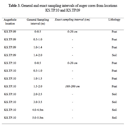
A total of 8 samples were collected for every 0.5-m interval from the surface to a depth of 5.5 m for borehole KS.TP.10, and four samples were collected from the surface to a depth of 2.0 m for KS.TP.09 (Mohamad Tarmizi, 2014). These samples for pollen analyses were taken every 10 cm along each core for regular core sampling intervals such as shown in Table 3 except for surface samples and samples for both radiocarbon dating and pollen analyses (Mohamad Tarmizi, 2014) which was taken at 180 to 200 cm (regular interval 2.0 to 1.5 cm) from borehole location KS.TP.10.
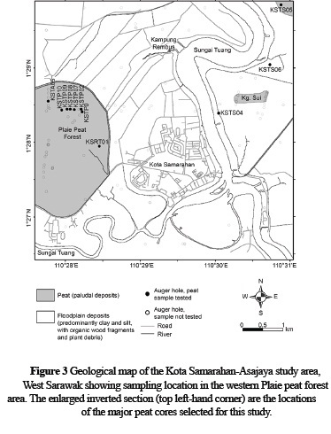
West Sarawak showing sampling location in the western Plaie peat forest area. The enlarged inverted section (top left-hand corner) are the locations of the major peat cores selected for this study.
The samples were treated in the laboratory with 10% KOH, sieved to remove larger pieces of plant material, undergone acetolysis and heavy liquid separation in zinc bromide/hydrochloric acid for the samples in which some mineral residue was present especially in some clayey peat or organic soil samples (Wood et al. 1996). The samples revealed considerable quantities of pollen grains and spores and counts varied from 26 to 266 grains per slide for KS.TP.10 and from 51 to 110 grains per slide for KS.TP.09.
The results of the pollen analysis are as shown in the diagram Figures 4 and 5 inclusive of all pollen and pteridophyte spores . Pollen types which could not be identified with any certainty were excluded from the pollen sum. In the analyses of the peat borehole profile of KS.TP.10, no extreme over-representation was observed and hence all pollen, and spore types have been included in the pollen sum. However, the over-representation of some peat pollen types may occur (for e.g. the Cephalomappa pollen) in peat swamps due low pollen dispersal when only a single prolific tree may produce the maximum pollen representation (Anderson and Muller, 1975). Also, misrepresentation or misinterpretation due to the absence of Shorea type pollen may also occur as Shorea type trees were observed present in the field at the locations of the studied augered holes (KS.TP.09 and KS.TP.10). The absence of pollen from Shorea type trees maybe due to the low pollen producing capability of these tree species.
The affinity of the types recognized is indicated on the pollen diagram either by reference to a living taxon or, if the type occurs in more than one taxon, by adding "type". The comparison was mainly limited to taxa known to occur in peat swamp forest, and in adjacent vegetational environments such as mangrove and riverine (or riparian) vegetation.
Description of the diagram
From the pollen diagram, it is possible to interpret the inferred succession of some forest types present in the locality of the augered holes (KS.TP.09 and KS.TP.10), and that these can be used to assess the past and current depositional environments represented by different sampling intervals from the augered hole profiles mentioned. The inferred succession of various forest types is described and discussed in the following sections.
Description of pollen diagram for borehole KS.TP.09.
A total of 4 samples were analyzed from the locality of borehole KS.TP.09 (Figure 3) (Tarmizi, 2014). Based on the pollen diagram (Figure 4) for the core profile from this augered hole and from the regular interval of 2.0 to 1.5 m, the Rhizophora and Oncosperma pollen is dominant along with a few grains of the Excoecaria aggulocha pollen. This range is also well marked by the occurrence of pollen originating from riparian vegetation which is Elaeocarpus and Eugenia. The Asplenium type spores with Acrostichum aureum and Stenochlaena palustris are also present, which represents non-arboreal pollen and spores. The sampling from 1.4 to 1.0 m shows a significant change in pollen assemblage, characterized by a decrease in the mangrove elements of Oncosperma and Rhizophora. This decrease continues with only 2 grains of Oncosperma pollen occurring at 0.5 to 1.0 m and the marked disappearance of the Rhizophora pollen from 1.4 to 1.0 m. From 2.0 to 1.4 m, there is a sharp increase of peat swamp pollen type Campnosperma and a decrease of the mangrove elements. At 1.4 m and the actual beginning of initial peat deposition, there is a prominent peak for Campnosperma. From 1.4 to 1.0 m, there is a marked decrease of Campnosperma and is accompanied by other peat swamp species which, however, are only present in low numbers such as Gonystylus, Cyrtostachys, Cephalomappa and Zalacca. The upper section between 1.4 to 0 m shows a decreasing trend of Campnosperma abundance but still shows dominance compared to other pollen types. The other types of peat swamp pollen present from 1.4 to 0 m in the peat section of the profile are Alangium, Calophyllum, Dillenia, Durio, Parastemon, Timonius, Shorea, Melanorrhea and Stemonurus. The pollen types Casuarina and Podocarpus are also recorded in this interval. The non-arboreal pollen and spores which characterize this range are represented by Asplenium type, Stenochlaena palustris, Polypodium, Pteris type and Lygodium microphyllum. Stenochlaena palustris has shown a significant trend as this spore is highly abundant from 1.4 to 1.0 m and shows a decreasing trend from 1.0 to 0 m. From 1.0 to 0.5 m, the pollen types found to include Cephallomappa, Callophyllum, Campnosperma, Palaquim, Parastemon, Zalacca followed by Oncosperma, Casuarina, Magnolia, Polypodium, Stenochlaena palustris, Durio and Eugenia.
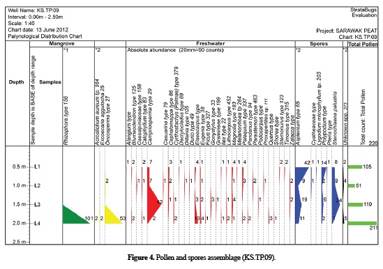
From 0.5 to 0 m, the significant pollen types that make up the peat swamp catena, as reported by Anderson and Muller (1975) and observed to occur here, are Stemonurus, Campnosperma, Palaquim and Dactylocladus. These are followed by less significant types such as Cephallomappa, Callophylum and Blumeodendron.
The abundance of Rhizophora and Oncosperma along with minor amounts of Excoecaria aggulocha between 2.0 to 1.5 m has revealed that the lower part of the inferred succession represents a former mangrove or estuarine swamp vegetational environment. The other important non-mangrove pollen types which are present in this zone are Elaeocarpus and Eugenia, which are locally subject to transportation by tidal action and are common species of riparian vegetation in Sarawak (Malaysia). These riparian type pollens may indicate and support the presence of a floodplain or a riverine depositional environment within this 2.0 to 1.4 m interval. A sharp floristic boundary is marked at 1.4 m. The zone between 2.0 to 1.4 m locally shows a sudden decrease in mangrove pollens such as Oncosperma and Rhizophora with the latter virtually disappearing at 1.4 m. This sharp decrease strongly indicates a transition zone from a mangrove to floodplain/riverine, to a peat swamp depositional environment. This zone may be comparable to the inferred succession of the peat swamp catena as studied and described by Anderson and Muller (1975) because it is characterized by the presence of significant pollen types of Campnosperma, Cyrtostachys and Zalacca. Hence, may strongly be comparable to the Campnosperma-Cyrtostachys-Zalacca sub-association characteristic of transitional mangrove to shallow peats occurring before the vegetational succession of Phasic Community I (Anderson and Muller, 1975). This is further supported by the abundance of typical climbing ferns, of the spore type Stenochlaena palustris especially at the lower part of the succession (1.5 m); this spore is common during the early development of peat swamps and is widely confined to the transitional mangrove-shallow peats (Campnosperma-Cyrtostachys-Zalacca sub-association), which occurs prior to succession of Phasic Community I (Anderson and Muller, 1975).
Description of pollen diagram for borehole KS.TP.10.
A total of 8 samples were analyzed from the locality of borehole KS.TP.10 (Figures 2 and 3). From 5.5 to 3.5 m, the Rhizophora pollen is present in relatively high percentages along with relatively high counts of the Oncosperma pollen. The Rhizophora pollens are still dominant from 3.5 to 2.0 m. However, this interval is marked by an increase of Campnosperma, along with minor proportions of other mangrove pollens such as Nypa fruticans, Avicennia and Excoecaria aggulocha. This range also records some prominent peaks from the riparian type pollens which are represented by Elaeocarpus and Eugenia. Towards the top of the succession between 1.5 to 1.0 m, the mangrove elements show sharp decreasing percentages, especially the Oncosperma and the Rhizophora pollen with the latter virtually disappearing (at 2.0 m). This interval represents a transitional assemblage and is characterized by a significant change in pollen assemblage which is then dominated by peat swamp taxa. The Campnosperma pollen is relatively dominant and is associated with typical peat swamp pollens such as Blumeodendron, Cyrtostachys, Zalacca and Parastemon.
In the upper part of the section from 1.0 to 0 m, the Campnosperma pollen is still dominant and is associated with other pollen types such as Gonystylus, Dillenia, Cephalomappa and Eugeissona. A peak from the Dactylocladus pollen was recorded at 1.0 m. In the uppermost part of the assemblage, from 0.5 to 0 m, the dominant pollen types observed to occur are Campnosperma followed by the presence of Blumeodendron, Gonostylus.
Parastemon and Stemonurus
The dominant non-arboreal pollens are represented by Asplenium type spores throughout the succession especially from 0.5 to 0 m, with some minor occurrences of Polypodium and Stenochlaena palustris. The Stenochlaena palustris is relatively more prominent from 2.0 to 1.0 m and shows an increasing trend before it virtually disappears in the interval 0.5 to 0 m.
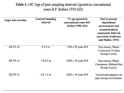
Based on the analyses of the pollen assemblage from this locality, the assemblage can be divided to represent four main vegetational phases or environments of deposition. At the interval 5.5 to 3.5 m, the dominance of Rhizophora and Oncosperma clearly demonstrates a former mangrove or estuarine swamp environment. This range is locally overlaid by the interval 3.5 to 2.0 m that is characterized by the abundant occurrence of Oncosperma, which is associated with the Nypa fruticans pollen. The dominance of Oncosperma and Nypa fruticans are widely confined to the inland zone of mangrove or estuarine vegetation. The peak of Elaeocarpus within this interval is probably related to tidal action or flooding which has brought an influx of this pollen type from riparian vegetational areas, and this relates to and supports a floodplain or riverine depositional environment. This zone may perhaps be comparable to the Campnosperma-Cyrtostachys-Zalacca sub-association zone as studied by Anderson and Muller (1975) and is interpreted to occur within the 2.0 to 1.0 m interval. This zone which is locally defined as shallow, topogenic peat is interpreted and derived from the association of the Campnosperma, Cyrtostachys and Zalacca pollen which is related to the initial development of peat or transitional phase from mangrove-floodplain to peat swamp environment. This is further supported by the abundance of Stenochlaena palustris peaking at 1.0 m. At the interval of 1.0 to 0.5 m, approximately 2380 ± 30 years B.P.(Mohamad Tarmizi, 2014) , it is still interpreted as a combination of shallow peat, and probably begins to change to Phasic Community I (Anderson and Muller, 1975) as this zone is locally characterized by the peak of Dactylocladus and the appearance of single pollen grain of Gonystylus. From 0.5 to 0 m near the surface, or approximately 1780 ± 30 years B.P. until present time (Mohamad Tarmizi, 2014), the pollens of Stemonurus and Gonostylus are observed present indicating that vegetational successive zonation of phasic community II has developed and may have been reached, but without the appearance of the Shorea type pollen (however, the large, Shorea type trees have been observed present in the field near to locations KS.TP.09 and KS.TP.10).
14C age of peat samples
Peat starts developing just above 200 cm from the profile at location KS.TP.10 which is near the centre of the peat basin and radiocarbon (14C) dating was attempted on a sample taken from 180 and 200 cm. An age of 2420 ± 30 years B.P. for the regular sampling interval 1.5 to 2 m (180 to 200 cm) was obtained for the age of initial deposition of peat into the tropical lowland peat basin studied (Table 4).
7. Discussion
Horizontal or lateral zonation in tropical lowland peat domes
Anderson (1961, 1964, 1976, 1983) and Anderson and Muller (1975) studied the domed topography of tropical peat deposits and the relationship between the concentric zonation of surface vegetation and increasing peat thickness, acidity and decreasing nutrient availability with horizontal distance between margin and centre of peat basin. Variations that occur in peat type within the deposits reflect the succession and lateral migration of the surface vegetation and the associated environment concurrent with coastal progradation (Murtedza et al. 2002, Anderson and Muller, 1975).
Buwalda (1940) in Paramanathan (2011) earlier did work in Sumatra, which supported the hypotheses/idea of horizontal zonality occurring in tropical lowland peats. He reported that different plant communities exist in the peat swamp forest depending on the thickness of the peat and the distance from the river (peat basin margin). In the central part of the peat forest, where the thickest peat deposits occurred, he observed that vegetation was poorly developed, with twisted and stunted trees and scattered pools of deep, acidic (pH value range of 3.0 to 3.5), brown water compared to vegetation occurring at shallower depths of peat (or peat deposited near or at the margin/boundary of peat dome/basin). However, on the peat deposits shallower than three meters deep, the soils had a pH of 3.5 to 4.5. Buwalda (1940) in Paramanathan (2011) reported six different vegetation types and zones occurring in the Indragiri area in Sumatra. Anderson (1961, 1963, 1964) also described six vegetation zones occurring in the lowland peat forests of Borneo and Brunei.
Anderson (1961, 1963, 1983) did a comprehensive study of the ecology of the Tropical Lowland Peat Swamp Forest. He observed and recorded 253 tree species that are mostly confined to the periphery of the peat swamp forest. According to Anderson (1963), most of the plant species that grow in the forests at the centre of the peat domes are mostly those that are usually found on nutrient poorer soils, such as podzols of the heath forest (Anderson, 1963). The Tropical Lowland Peat Swamp Forests in Sarawak, Malaysia and adjacent Brunei show lateral or horizontal changes in vegetation types from its periphery to the centre of the dome-shaped peat swamps and each of the six dominant lateral vegetation zone was designated "Phasic Community'' by Anderson (1961). Six distinct Phasic Communities or successive lateral vegetation zones were recognized based on their floristic composition and structure of vegetation in each Phasic Zone (Anderson, 1961; Paramananthan, 2011) and were numbered Phasic Community I at the margin to Phasic Community VI in the centre of the peat swamp (Table 5).

Discussion on palynological analysis
In general, palynological analysis has provided information regarding the locally inferred succession of a tropical lowland peat swamp vegetation. The pollen succession interpreted from the location at KS.TP.10 near the lowland tropical peat dome centre is comparable to a normal peat development which starts on mangrove clay. Based on the pollen analysis and comparison to the inferred plant succession as studied and published by Anderson and Muller (1975), the peat deposit is concluded as local and autothochthonous and includes the phasic communities of I to II. Field observations have noted the presence of large Shorea type species of trees with wide girths (1 to 3 m) along the traverse section from KS.TP.09 to KS.TP.10 which further supports that the vegetational zonation has reached Phasic Community II (at an interval of 0.5 to 0 m) even though the pollen of Shorea type is scarce and not observed in the studied profile of KS.TP.10.
From 5.5 to 2.0 m, it is clear that mangrove or estuarine elements dominate. From 5.5 to 3.5 m, the dominance of Rhizophora and Oncosperma (Plate 1) is evidence of a former mangrove swamp environment (Anderson and Muller, 1975). From 3.5 to 2.0 m there is the abundant occurrence and dominance of the Oncosperma and Nypa fruticans pollen which largely represents the inland zone of mangrove vegetation. The peak of Elaeocarpus at 2.5 m in the 3.0 to 2.5 m interval is probably related to an influx of pollen from riparian type vegetation due to a freshwater influx or floodwaters, and the interval may thus represent and support a riverine floodplain depositional environment setting. Overall, the analyses of the pollen succession at 2.0 to 1.5 (or at approximately 2420 ± 30 years B.P.) is indicative of a mangrove to shallow peat swamp transition zone interpreted to have developed near to the coast and which usually occurs before phasic community I (Anderson and Muller, 1975) and is indicated by the Campnosperma-Cyrtostachys-Zalacca sub-association (Anderson and Muller, 1975).
From 1.5 to 1.0 m, the presence of peat pollen types that may support the vegetational successions or zones ranging from phasic community I and phasic community IV to VI is noted (Anderson and Muller, 1975). Pollen types such as Blumeodendron that are known to be abundant in phasic community I (Anderson and Muller, 1975), Campnosperma (abundant in PC I), Parastemon (abundant in PC I and PC IV to VI) and Stenochlaena palustris (abundant in mangrove to shallow peat transition zones and PC I) are also present (Anderson and Muller, 1975). However, peak abundance of Stenochlaena palustris occurs at this interval, thus signifying vegetation succession of phasic community I. From 1.0 to 0.5 m, at approximately 2380 ± 30 years B.P., the presence of peat pollen types that may support the vegetational succession of phasic community zones that range from phasic community I to VI is observed (Anderson and Muller, 1975). Pollen types like Dactylocladus (abundant in PC I to VI), Pandanus (abundant in PC I to V) and Parastemon (abundant in PC I and PC IV to VI) are also present in this interval as observed by Anderson and Muller (1975). However, Stenochlaena palustris and Zalacca (Plate 1) is still present, which implies that the zonation may still be only in the phasic community I.
From 0.5 to 0 m at location KS.TP.10, or approximately at 1780 ± 30 years B.P. until the present time, is noted the presence of peat pollen types that may support the occurrence of vegetational successions or zones ranging PC I to PC VI. Pollen types like Callophylum (abundant in PC I to PC IV), Gonostylus (abundant in PC IV), Blumeodendron (abundant in PC I), Campnosperma (locally abundant near coastal margin of PC I), Cephallomappa (abundant in PC II to III), Eleocarpus (abundant in PC I to IV) and Parastemon (abundant in PC I and PC IV to VI) are present (Anderson and Muller, 1975). In this interval, however, the Stenochlaena palustris and Zalacca pollen were observed not to be present, which implies that the zonation may no longer be Phasic Community I. Hence, the zonation may have reached to be at least Phasic Community II (or higher). As mentioned earlier, field observations support and have noted the presence of large, hollow, scattered Shorea type (Table 5) species of trees (abundant in PC II to IV according to Anderson and Muller, 1975).
8. Conclusion
From field identification and von Post classification as well as pollen analysis of the augered peat samples (KS.TP.09 and KS.TP.10) at the western peat forest of the study area, the findings could be summarized as follows:
1) Field identification and classification (von Post) of the vertical, top to the bottom peat layer on the tropical lowland peat dome in the western part of the study area shows that there is a vertical variation of peat humification levels for every 0.5 m interval, in the form of dominantly occurring decomposition levels of hemic to sapric (H6 to H7), hemic (H5 to H6), hemic (H4 to H6) and fibric to hemic (H3 to H5), respectively, at KS.TP.10; and sapric (H7 to H8), hemic to sapric (H6 to H7) and hemic (H5 to H6), respectively, at location KS.TP.09, with both profiles generally indicating a vertical decrease of humification levels with peat depth.
2) The proposed Phasic Communities inferred vegetational zonation that were observed to occur vertically, from the top to the bottom of the studied augered peat profiles near the centre of the tropical lowland peat dome are Phasic Community II (Alan Swamp Forest), Phasic Community I (Mixed Peat Swamp Forest) followed by the underlying transitional mangrove to peat swamp shallow/marginal peats, respectively.
3) Based on pollen analyses and field observations, it can be concluded that most of the studied peat profiles from locations KS.TP.10 and KS.TP.09 were part of a progradation deltaic succession whereby a floodplain depositional environment is progressively replacing a mangrove swamp environment followed by a peat swamp environment. The peat swamp phasic communities inferred succession (bottom to top of peat profile) interpreted in this study is similar to that as studied by Anderson and Muller (1975) in the sense that it ranges from a transitional mangrove to peat swamp environment (or shallow/marginal peats) to a normal open swamp Phasic Community I (Mixed Peat Swamp Forest) that may have developed and extends up to at least Phasic Community II (Alan Swamp Forest) at present. Also, field observations and the presence of large, hollow, scattered Shorea type trees, supports that the surface, vegetational zonation of the studied tropical lowland peat dome may have reached Phasic Community II, at the least. Also, there are pollen types that are found to occur or are also abundant in PC III and PC IV or more from pollen evidence and analysis, as previously reported by Anderson and Muller (1975).
4) It is interpreted that the depositional environment at the location of the profile seems to commence on a mangrove swamp environment which, due to a continued regression of sea levels, gave rise to a more inland mangrove swamp environment with an increased riparian influence. Peat then starts to develop in a transitional mangrove to floodplain (or floodbasin), and followed by a shallow, topogenic peat depositional environment at approximately 2420 ± 30 years B.P. This shallow/marginal topogenic peat swamp assemblage with riparian influence then starts to develop with an inferred peat vegetational succession (Anderson and Muller, 1975) reaching phasic community I (at approximately 2380 ± 30 years B.P.) and phasic community II (at approximately 1780 ± 30 years B.P. until present time), towards the upper part of the now ombrogenic peat profile.
5) It is concluded from pollen analyses of the augered core profiles of both KS.TP.10 and KS.TP.09, that estuarine and deltaic brackish to saline water influence may have gradually ceased at approximately 0.5 m below the lithological boundary between peat and soil. As a result, this approximately 0.5 m thick soil or slightly organic to organic soil layer consisting of floodplain or floodbasin deposits and laying between the peat and estuarine/deltaic deposits was increasingly deposited by flooding river waters after or with the gradual decline of mangrove or estuarine influence due to receding sea levels.
Acknowledgements
The authors have no conflict of interests. The authors are thankful to all anonymous reviewers that have contributed constructive comments to improve this manuscript considerably. The authors also acknowledge the IPPP grant PV018-(2011A) and Bantuan Khas Penyelidikan (BKP) grant no BK064-2015 for financial support from the University of Malaya. The authors are grateful, appreciate and acknowledge the assistance and scholarship/study leave (HLP) from the Minerals and Geoscience Department of Malaysia (JMG), Public Services Department of Malaysia, Forestry Department of Malaysia and The Ministry of Natural Resources and Environment of Malaysia.
References
Anderson, J.A.R. (1961). The ecology and forest types of the peat swamp forests of Sarawak and Brunei in relation to their silviculture. Ph.D. Thesis, University of Edinburgh, United Kingdom.
Anderson, J.A.R. (1963). The Flora of the Peat Swamp Forests of Sarawak and Brunei, including a catalogue of all recorded species of flowering plants, ferns and fern allies. Garden's Bulletin 20, 131-228.
Anderson, J.A.R. (1964). The structure and development of the peat swamps of Sarawak and Brunei. The Journal of tropical geography, 18, 7-16.
Anderson, J.A.R. (1976). Observations on the ecology of five peat swamp forests in Sarawak and Kalimantan. Soil Research Institute Bogor, 3, 45-55.
Anderson, J.A.R. (1983). The tropical peat swamps of Western Malesia. In: Gore AJP (ed) Ecosystems of the World, Vol. 4B, Mires: Swamp, Bog, Fen and Moor. Elsevier Scientific Publishing Company, Amsterdam, 181-199.
Anderson, J.A.R. and Muller, J. (1975). Palynological study of a Holocene peat and Miocene coal deposit from NW Borneo. Review of Palaeobotany and Palynogy, , 19(4), 291-351. DOI: 10.1016/0034-6667(75)90049-4.
Andriesse, J.P. (1988). Nature and management of tropical peat soils. FAO Soils Bulletin 59. Food and Agriculture Organisation of the United Nations, Rome.
Buwalda, P. (1940). Bosverkenning in de Indragirische Bovenlanden. Rep For Res Sta, Bogor, Indonesia (Unpub).
Engineering Geology Working Group. (2007). Guideline for Engineering Geological Investigation in Peat and Soft Soils. Minerals and Geoscience Department of Malaysia.
Huat, B.B.K. (2004). Organic and peat soils engineering. Universiti Putra Malaysia Press, Serdang.
Fitzpatrick, R.W., Merry, R.H., Williams, J., White, I., Bowman, G. and Taylor, G. (1998). Acid sulfate soil assessment: coastal, inland and minesite conditions. National Land and Water Resources Audit Methods Paper, Australia.
Jarret, P.M. (1995). Geoguide 6. Site investigation for Organic Soils and Peat. JKR Document 20709-0341-95. Institut Kerja Raya, Malaysia.
Lam, S.K. (1989). Quaternary Geology of the Kota Samarahan Area, Sarawak. Geological Survey Department of Malaysia.
Murtedza, M., Padmanabhan, E., Mei, B.L.H., and Siong, W.B. (2002). The peat soils of Sarawak. In: STRAPEAT (Strategies for implementing sustainable management of peatlands in Borneo) Status Report. University Malaysia Sarawak, Sarawak.
Paramananthan, S. (2011). Keys to the identification of Malaysian soils according to parent materials (Mimeo). Param Agricultural Soil Surveys, Selangor, Malaysia.
Mohamad Tarmizi, M.Z. (2014). Peat Stabilization, Organic Geochemistry and Related Palynological Characteristics of a Tropical Lowland Peat Basin in The Kota Samarahan-Asajaya Area, West Sarawak, Malaysia (Ph.D. Thesiss). University of Malaya, Kuala Lumpur.
Mohamad Tarmizi M.Z., Ng T.F., Kuna Raj J., Azman Ghani, Mustaffa K. S., Hashim R., Ashraf M.A., (2013a). Definitions and engineering classifications of tropical lowland peats. Bull Eng Geol Environ. DOI 10.1007/s10064-013-0520-5.
Mohamad Tarmizi M.Z., Ng T.F., Wan Hasiah A., Kuna Raj J., Paramananthan S., Hashim R., Ashraf M.A., (2013b). Distribution, classification, petrological and related geochemical (SRA) characteristics of a tropical lowland peat dome in the Kota samarahan-Asajaya area, West Sarawak, Malaysia. Cent Eur J Geosci 5:285-314.
Mohamad Tarmizi M.Z., Ng T.F., Wan Hasiah A., Kuna Raj J., Azman Ghani, Mustaffa K. S., Ashraf M.A., (2013c). Geochemical characteristics of a tropical lowland peat dome in the Kota Samarahan-Asajaya area, West Sarawak, Malaysia. Environ Earth Sci DOI 10.1007/s12665-014-3504-2.
Tie, Y.L. (1990). Studies of peat swamps in Sarawak with particular reference to soil-forest relationships and development of domed shaped structures. Ph.D. Thesis, London Metropolitan University, England.
United States Department of Agriculture (1998). Keys to Soil Taxonomy, 8th edition. Natural Resources Conservation Service, Washington D.C.
Von Post, L. (1922). Sveriges geologiska undersoknings torvinventering och nagre av dess hittills vunna resultat, Sr. Mosskulturfor. Tidskr, 1,1-27.
Wilford, G.E. (1960). Radiocarbon age determinations of quaternary sediments in Brunei and northeast Sarawak. British Borneo Geological Survey, Annual Report 1959.
Wood, G.R., Gabriel, A.M., Lawson, J.C. (1996). Palynological techniques-processing and microscopy. In Jansoniun J and McGregor DC (eds), Palynology: principle and application, American Association of Stratigraphic Palynologist Foundation, Dallas, 29-50.
Yogeswaran, M. (1995). Geological considerations in the development of Kuching area dialogue session. Geological and geotechnical considerations in civil works, Geological Survey of Malaysia, Kuala Lumpur.
How to Cite
APA
ACM
ACS
ABNT
Chicago
Harvard
IEEE
MLA
Turabian
Vancouver
Download Citation
CrossRef Cited-by
1. K. Prabakaran, S. Eswaramoorthi, R. Nagarajan, A. Anandkumar, F. Merlin Franco. (2020). Geochemical behaviour and risk assessment of trace elements in a tropical river, Northwest Borneo. Chemosphere, 252, p.126430. https://doi.org/10.1016/j.chemosphere.2020.126430.
2. Ying Liu, Zengxue Li, Dongdong Wang, Xiaojing Li, Xue Zheng, Haiyan Liu, Jiamin Liu, Zengyao Li. (2023). The genetic characteristics of intermittency and continuity in peat formation and accumulation processes. Ore Geology Reviews, 161, p.105650. https://doi.org/10.1016/j.oregeorev.2023.105650.
Dimensions
PlumX
Article abstract page views
Downloads
License
Earth Sciences Research Journal holds a Creative Commons Attribution license.
You are free to:
Share — copy and redistribute the material in any medium or format
Adapt — remix, transform, and build upon the material for any purpose, even commercially.
The licensor cannot revoke these freedoms as long as you follow the license terms.


