


Published
Case Study of the Characteristics and Dynamic Process of July 10, 2013, Catastrophic Debris Flows in Wenchuan County, China
DOI:
https://doi.org/10.15446/esrj.v20n2.48026Keywords:
Debris flow, dynamic process, the block and burst characteristics, prevention and cure measures, flujo de detritos, procesos dinámicos, características de bloqueo y ruptura, medidas de prevención. (en)The Wenchuan earthquake of May 12, 2008, generated a significant amount of loose solid material that can produce devastating debris flows. In the five years since the earthquake, there have been many large-scale individual and group catastrophic debris flows that have caused lots of damage to the resettled population and the reconstruction efforts. The reconstructed towns of Yingxiu, Yinxing and Miansi have suffered debris flows and other secondary disasters in the past five years and are still not out of danger in the future. A debris-flow catastrophic event hit four towns of Wenchuan County along the Duwen Highway, part of China’s National Highway 213, at midnight on July 10, 2013, following a local extreme rainfall of 176.2mm 24h-1. The debris flows occurred simultaneously along seven gullies. A total of 15000 people were affected due to the destruction of resettlement areas, factories, power stations, and houses. Because of this devastating event, traffic along the Duwen highway was completely disrupted during the disaster and recovery period. The present study focuses on the Lianshan Bridge debris flow gully; the disaster characteristics and cause of the debris flow were analyzed based on field investigations, remote sensing interpretation, and laboratory experiments. The particular dynamic parameters of the debris flow were calculated and analyzed including density, velocity, discharge, total volume and impact force. Also, the dynamic processes and changes that occurred in the debris flow were examined, and the block and burst characteristics of debris flow were studied based on statistical calculation and analysis dynamic characteristic parameters of debris flow. Finally, a program to prevent further debris flow was proposed according to the on-site investigation and based on the analysis of the features and dynamic processes of the debris flow.
Resumen
El terremoto de Wenchuan, el 12 de mayo de 2008, generó una gran cantidad de material sólido suelto que puede producir flujos de detritos devastadores. En los años posteriores al terremoto han ocurrido deslizamientos a gran escala individuales y simultáneos que han causado daño a los habitantes reubicados y a los esfuerzos de reconstrucción. Las ciudades reconstruidas de Yingxiu, Yinxing y Miansi han sufrido flujos de detritos y otros desastres secundarios desde el terremoto, y no están exentas de eventos futuros. Un evento simultáneo de flujo de detritos afectó a cuatro localidades del condado de Wenchuan, a lo largo de la autopista de Duwen, parte de la carretera nacional 213, en la medianoche del 10 de julio de 2013, después de una lluvia extrema de 176,2 mm 24h-1. Los movimientos de detritos ocurrieron en siete pendientes. Un total de 1500 personas resultaron afectadas debido a la destrucción en áreas de reasentamiento, fábricas, estaciones eléctricas y viviendas. Debido a este devastador hecho, el tráfico de la autopista Duwen estuvo interrumpido durante el período del desastre y mientras se recuperaba la zona. Este estudio se enfoca en el deslizamiento del Puente Lianshan, donde se analizaron las características y las causas del flujo de detritos basados en investigaciones de campo, interpretación de detección remota y experimentos de laboratorio. Se calcularon y analizaron los parámetros dinámicos particulares del flujo de detritos como la densidad, velocidad, descarga, volumen total y fuerza de impacto. También se analizaron los procesos dinámicos y los cambios que ocurrieron en el flujo de detritos, al igual que se estudiaron las características de bloqueo y ruptura del flujo con base en cálculos estadísticos y análisis de los parámetros dinámicos característicos. Finalmente, se propone un programa para prevenir mayores movimientos de detritos de acuerdo con la investigación de campo y basado en los análisis de las características y procesos dinámicos del flujo de material sólido suelto.
Doi: https://doi.org/10.15446/esrj.v20n2.48026
Case Study of the Characteristics and Dynamic Process of July 10, 2013, Catastrophic Debris Flows in Wenchuan County, China
Características y procesos dinámicos de los catastróficos movimientos de detritos en el condado de Wenchuan, China, el 10 de julio de 2013 - Caso de estudio
Gui-Sheng Hu1, Ning-Sheng Chen1,*, Javed Iqbal Tanoli1,2, Yong You1 and Jun Li1
1 Key Lab of Mountain Hazards and Surface Processes, Institute of Mountain Hazards and Environment, Chinese Academy of Sciences, 610041, Chengdu, China. Tel: +86-18683259117. Email: huguisheng@imde.ac.cn.
2 Department of Earth Sciences, COMSATS Institute of Information Technology, Abbottabad, 22060, Pakistan
* Corresponding author: chennsh@imde.ac.cn
Record
Manuscript received: 23/12/2014 Accepted for publication: 13/05/2016
How to cite item
Hu, G. S., Chen, N. S., Tanoli, J. I., You, Y., & Li, J. (2016). Case Study of the Characteristics and Dynamic Process of July 10, 2013, Catastrophic Debris Flows in Wenchuan County, China. Earth Sciences Research Journal, 20(2), E1-E13. doi: https://doi.org/10.15446/esrj.v20n2.48026
ABSTRACT
The Wenchuan earthquake of May 12, 2008, generated a significant amount of loose solid material that can produce devastating debris flows. In the five years since the earthquake, there have been many large-scale individual and group catastrophic debris flows that have caused lots of damage to the resettled population and the reconstruction efforts. The reconstructed towns of Yingxiu, Yinxing and Miansi have suffered debris flows and other secondary disasters in the past five years and are still not out of danger in the future. A debris-flow catastrophic event hit four towns of Wenchuan County along the Duwen Highway, part of China's National Highway 213, at midnight on July 10, 2013, following a local extreme rainfall of 176.2mm 24h-1. The debris flows occurred simultaneously along seven gullies. A total of 15000 people were affected due to the destruction of resettlement areas, factories, power stations, and houses. Because of this devastating event, traffic along the Duwen highway was completely disrupted during the disaster and recovery period. The present study focuses on the Lianshan Bridge debris flow gully; the disaster characteristics and cause of the debris flow were analyzed based on field investigations, remote sensing interpretation, and laboratory experiments. The particular dynamic parameters of the debris flow were calculated and analyzed including density, velocity, discharge, total volume and impact force. Also, the dynamic processes and changes that occurred in the debris flow were examined, and the block and burst characteristics of debris flow were studied based on statistical calculation and analysis dynamic characteristic parameters of debris flow. Finally, a program to prevent further debris flow was proposed according to the on-site investigation and based on the analysis of the features and dynamic processes of the debris flow.
Keywords: Debris flow, dynamic process, the block and burst characteristics, prevention and cure measures.
RESUMEN
El terremoto de Wenchuan, el 12 de mayo de 2008, generó una gran cantidad de material sólido suelto que puede producir flujos de detritos devastadores. En los años posteriores al terremoto han ocurrido deslizamientos a gran escala individuales y simultáneos que han causado daño a los habitantes reubicados y a los esfuerzos de reconstrucción. Las ciudades reconstruidas de Yingxiu, Yinxing y Miansi han sufrido flujos de detritos y otros desastres secundarios desde el terremoto, y no están exentas de eventos futuros. Un evento simultáneo de flujo de detritos afectó a cuatro localidades del condado de Wenchuan, a lo largo de la autopista de Duwen, parte de la carretera nacional 213, en la medianoche del 10 de julio de 2013, después de una lluvia extrema de 176,2 mm 24h-1. Los movimientos de detritos ocurrieron en siete pendientes. Un total de 1500 personas resultaron afectadas debido a la destrucción en áreas de reasentamiento, fábricas, estaciones eléctricas y viviendas. Debido a este devastador hecho, el tráfico de la autopista Duwen estuvo interrumpido durante el período del desastre y mientras se recuperaba la zona. Este estudio se enfoca en el deslizamiento del Puente Lianshan, donde se analizaron las características y las causas del flujo de detritos basados en investigaciones de campo, interpretación de detección remota y experimentos de laboratorio. Se calcularon y analizaron los parámetros dinámicos particulares del flujo de detritos como la densidad, velocidad, descarga, volumen total y fuerza de impacto. También se analizaron los procesos dinámicos y los cambios que ocurrieron en el flujo de detritos, al igual que se estudiaron las características de bloqueo y ruptura del flujo con base en cálculos estadísticos y análisis de los parámetros dinámicos característicos. Finalmente, se propone un programa para prevenir mayores movimientos de detritos de acuerdo con la investigación de campo y basado en los análisis de las características y procesos dinámicos del flujo de material sólido suelto.
Palabras clave: Flujo de detritos, procesos dinámicos, características de bloqueo y ruptura, medidas de prevención.
1. Introduction
Numerous landslides have been triggered in earthquake-affected areas and the largest ones have been located close to the rupture faults (Chen et al. 2009; Huang et al. 2012). Abundant loose solid erodible material from co-seismic rock falls and landslides are then deposited in gullies, which form the source material for debris flows (Shieh et al. 2009). Numerous debris flows have been triggered during the rainy season in the years following an earthquake (Yu et al. 2014). The frequency and magnitude of debris flows were thus increased significantly after the Wenchuan earthquake of 2008 (Cui et al. 2011; Chen et al. 2013); during the rainy seasons in the past five years, over 800 debris flows have occurred and this has caused great damage to the resettled population and the reconstruction efforts (Zhang et al. 2013). Although mitigation measures were constructed in a few gullies such as the Wenjia and Bayi Gullies, disastrous debris flows still occurred; in some small gullies the mitigation measures installed proved to be inadequate and incomplete (Wang et al. 2012, 2013). For example, a catastrophic debris-flow event hit four towns in Wenchuan County along the Duwen highway, part of the China National Highway G213, at midnight on July 10, 2013; this event broke out simultaneously in seven debris flow gullies. A total of 15000 people were affected; 18 people were reported dead or missing and there was significant destruction of resettlement areas, factories, power stations and houses (Table 1). These debris-flow gullies located along the Duwen highway have seen reoccurring debris flow disasters in the geological history, and it is likely that some part of these gullies will have another debris flow disaster in the near future. Debris flow activity of these small gullies is still very active and poses a serious threat to the local population, property, traffic safety, and the development of the local social economy. Thus, debris flow mitigation measures should be installed in a timely fashion (Xu et al. 2012). Using the Lianshan Bridge debris flow gully as an example, an analysis was performed on the disaster characteristics, cause of the debris flow, the dynamic processes and the changes in the debris flow through field measurements, remote sensing interpretation, and laboratory experiments. It is essential to provide a comprehensive debris flow control scheme which will lay the foundation for future research on regional debris flows.

2. Study area
2.1 Location of the study area
The Lianshan Bridge debris flow gully is located in Yinxing Town, Wenchuan County, Sichuan Province of China. It is the first order and left branch of the Minjiang River (Figure 1), with coordinates 103°29′49″E, 31°11′24″N at the gully mouth. The catchment covers an area of 0.7 km2 and the main channel is 1.34km long with a 48.3% longitudinal slope. The flow direction of the gully is from west to east. The dimensions of the watershed from east to west and south to north approximately 3.0 and 4.0 km, respectively. The gully is accessible to traffic via the Duwen highway that passes through its deposition area.

2.2 Landform conditions
The study area, located on the eastern edge of the Qinghai–Tibetan Plateau, has a complex terrain characterized by considerable elevation differences and steep slopes (Zhang et al. 2006). High mountains, deep-cut rivers, and steep slopes are the main landform characteristics of this area. The elevation difference of the gully is 1159 m from the maximum elevation of 2184m in the west of the catchment to the minimum elevation of 1025 m at the gully mouth.
2.3 Geological conditions
The geological conditions of the study area are complex; earthquakes occur frequently and cause significant destruction to mountain surface. The “5.12” Wenchuan earthquake that occurred in this area was due to the Longmen Mountain Fault zone. The gully is in the Cathaysian tectonic belt, very close to the deep fracture zone of the Maoxian-Wenchuan reverse fault (Longmen Mountain Fault zone), which lies in the southwest to northeast direction (Zhou et al. 2000). The strata exposed in the gully include diorite (δ23) in the upper reaches, plagioclase granite (γo24) in the middle reaches, and granodiorite (γδ23) in the lower reaches. The rock mass of the study area belongs to the magmatic rock formed in the Jinning-Chengjing Period with structural characteristics of high strength, joint fissures, and strongly weathered layers at the surface. Consequently, it is prone to instability, collapse and landslides.
The Lianshan Bridge Gully is located in the area of the active fault. Furthermore, the gully is situated about 5 km from the epicenter of the Wenchuan earthquake. The earthquake caused widespread destruction in the catchment of Lianshan Bridge Gully and formed a large number of landslips and landslides, providing a rich source of loose solid material for the debris flows. Based on “the ground motion parameter zoning map of the Wenchuan earthquake” (GB18306-2001), the study area belongs to the high-intensity seismic region (VIII degrees) with peak ground acceleration of 0.2 g and characteristic period of seismic response spectrum of 0.35 s.
2.4. Rainfall
The study area is in the subtropical humid monsoon climate zone of the Sichuan Basin border and it is situated within the rainstorm center of the west Sichuan region. According to the observation data from the Wenchuan meteorological station, the average annual rainfall is 932.6mm, and the maximum and the minimum annual rainfalls are 1277 and 754 mm, occurring in 1992 and 1998, respectively. The maximum daily rainfall can be up to 166.7mm mm. Precipitation over the year is unevenly distributed, concentrated mainly in the period May to September (Figure 2), which accounts for 79% of the annual rainfall. This period usually has a large number of collapses, landslides, debris flows, and other geological disasters (Liu et al. 2010). In short, the water source condition is favorable to the formation of debris flows in the Lianshan Bridge Gully.

3. Methodology
3.1 Field investigations
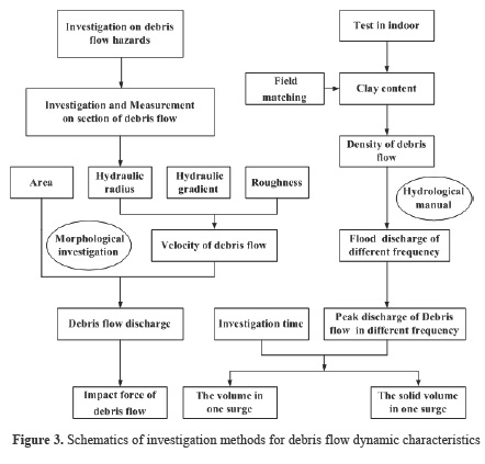
This research used field investigations, remote sensing interpretation and model calculation to determine the dynamic characteristics of the debris flow. The steps taken to collect and analyze the data are shown in Figure 3. Field work was conducted from July 12 to August 28, 2013, by interviewing local residents to ascertain the debris flow history in Lianshan Bridge gully (We will visit and inquiry many local residents of different ages in near Lianshan Bridge gully. Some older local residents can remember their grandparents, parents who tell them the history of debris flow disasters. We ascertain the frequency of the debris flow disasters based on investigative information) and show that the “7.10” debris flow was the largest debris flow in the past century in this gully. A 1:1000 topography map of the deposition area and a 1:200 cross-section map of the downstream channels are given in Figure 4A and B. As shown in Figure 4, nine test pits in the downstream channel and debris flow samples at six sites (S1–S6) from the downstream channel and debris fan were collected for sieving and particle gradation analysis (Figure 4A and C). Field and laboratory dry sieving tests were conducted following the British Standards (Chen et al. 2012). The seven materials identified (smaller than 2 mm diameter) were tested further using laboratory dry sieving tests. Grain sizes were determined by using field weighing and laboratory particle size analysis techniques, from which the debris flow bulk density was then obtained.

3.2 Parameter calculating
3.2.1 Density of debris flow
Density of debris flow was calculated using field matching and statistical analysis methods.
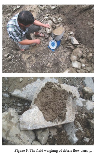
a. The field matching method
In the field matching method, first of all, we measured the size of bucket before sampling, and then we can calculate the volume of samples. Secondly, soil samples were uniformly mixed in the field in order to help local residents to compare it with 7.10 debris flow (Figure 5). Finally, we got the weight of the soil samples, and at the same time we can use these data to calculate the mean value of debris flow density. We select five soil samples to calculate debris flow density; the results of debris flow density are shown in table 2.
b. The statistical analysis method.
The density of debris flow was calculated using the Formula 1 (Chen et al. 2003). This formula was obtained from data collected from a large number of debris flow gullies located in the southwest region of China; this reflected the relationship between the percentage of clay particles in the debris flow (< 0.005mm) and the density of the debris flow.

where γ ϲ is the density of the debris flow (kg/m³), and ˟ is the percentage of clay particles in the debris flow. Formula 1 is mainly suitable for the calculation of the viscous debris flow density that clay content of debris flow is less than 10%.
The percentage of debris flow clay particles was obtained by particle size analysis tests conducted in the laboratory, and the results of debris flow density with clay content are shown in table 3.

The debris flow density of Lianshan Bridge debris flow gully is 1940kg/m³ according to the calculation results of the above two methods.
3.2.2 Velocity of debris flow
The velocity of the viscous debris flow was calculated using the experiential Formula 2 (Chen et al. 2011a), which was obtained from statistical data of a large number of debris flow gullies located in the southwest region of China.

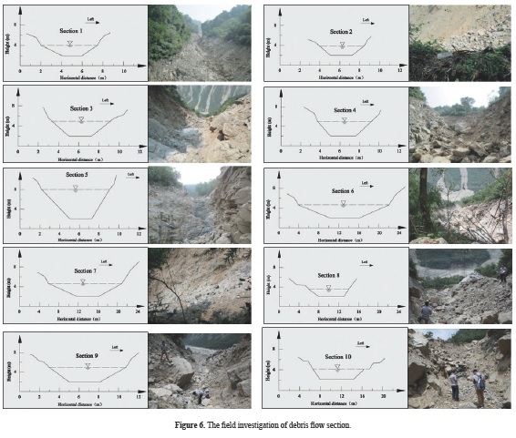
where Vc is velocity of the viscous debris flow (m/s); nc is the roughness values of debris flow gully, the nc is empirical coefficient that it was determined by the hydraulic radius of the debris flow; Hc is the hydraulic radius of the debris flow (m); Ic is the longitudinal gradient of debris flow gully bed (‰). The hydraulic radius and longitudinal slope of 10 debris flow sections were measured from the top of gully to the gully mouth (Figure 6). The velocity of 10 debris flow sections were calculated through these acquired parameters, and the results are showed on the Table 4.

3.2.3 The discharge of debris flow
The peak discharge of debris flow Qc was calculated by both the morphological investigation method and the hydrological manual method.
a. The morphological investigation method
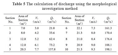
The discharge of debris flow based on the morphological investigation method was calculated using the area of each debris flow section and the corresponding velocity of debris flow. The results are showed in Table 5.
b. The hydrological manual method.
Firstly, the flood peak discharge (QP) of Lianshan Bridge gully was determined in order to calculate the debris flow peak discharge (Qc). The flood peak discharge (QP) can be calculated by Formula 3 that the flood peak discharge calculated from this formula is more suitable for the southwest region of China (Ni et al. 2012), and the results are given in Table 6.


where A is the watershed area of debris flow gully; ψ is the runoff coefficient of the flood peak; S is the rainfall intensity; τ is the runoff confluence time of the rainstorm, and n is the attenuation index of the rainstorm; L is the length of debris flow gully; J is the mean gradient of debris flow gully bed; P is the rainstorm frequency, for example, P=1% means that the rainstorm was a once-in-a-century.
The debris flow peak discharge (Qc) can be calculated using the Formula 4.

where DU is the blockage coefficient in the debris flow gully. Usually, the degree of blockage is classified as very serious blockage (DU=3.0–2.5), serious blockage (DU=2.5–2.0), normal blockage (DU=2.0–1.5) and minor blockage (DU=1.5–1.0). For the situation in the Wenchuan earthquake area, the values were calculated to be 5.5–4.5, 4.5–3.5, 3.5–2.5 and 2.5–1 (You et al. 2012). Based on the field investigation and the channel blockage as identified from aerial photography, the blockage coefficient for the Lianshan Bridge gully is considered to be 2 and 3. is the increase coefficient of debris flow peak discharge, which can be calculated (Formula 5) as follows.

where γw is the density of water (kg/m3), usually determined as 1000 kg/m3; γs is the density of the solid material (kg/m3), usually determined as 2650kg/m3, and γc is the density of debris flow (kg/m3).
3.2.4 The total and solid volume of debris flow
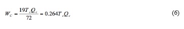
The total and solid volumes of debris flow were calculated using the experiential Formulae 6 and 7(Chen et al. 2011b). The results are given in Table 7.


where WC is the total volume of debris flow (m³); TC is duration of the debris flow (s); QC is the debris flow peak discharge (m³/s); γw is the density of water (kg/m³); γC is the density of the debris flow (kg/m³); γs is the density of the solid material (kg/m³); is the solid volume of the debris flow.
3.2.5 The impact force of the debris flow
The impact force of debris flow is an important parameter in debris flow control engineering design that includes the impact force of the debris flow due to the dynamic pressure and the maximum stone size.
a. The impact force of debris flow dynamic pressure
The impact force of the debris flow due to the dynamic pressure was calculated using the Formula 8 (He and Wu 2009). The results are shown in Table 8.


where σ is the impact force of the debris flow due to the dynamic pressure (kg/m²); ᵧc is the density of the debris flow (kg/m³); λ is the building shape coefficient, usually determined as 1.33 when the building is rectangular; Vc is velocity of debris flow (m/s); σ is the angle between the buildings and the stress surface pressure direction, which is usually determined as 90°.
b. The impact force of the maximum stone size
The impact force of debris flow dynamic pressure resulting from the maximum size of individual stones was calculated by the Formula 9 (He and Wu, 2009). The results are shown in the Table 9.

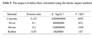
where F is the impact force of the maximum article size in the debris flow (kN); Kc is the correction coefficient and usually determined as 0.1; Rs2 is the radius of the maximum stone size and determined as 2.9m; V1 is the Poisson's ratio of material and V2 is Poisson's ratio for the maximum stone size; m2 is quality of the maximum stone (kg) in the gully; V is relative velocity of the stones (m/s) and determined as the 70% of Vc ; is the modulus of elasticity of binding material and is modulus of elasticity of the maximum stones (kg/m²).
4. Disaster characteristics
4.1 Triggering rainfall
4.1.1 The previous rainfall amount
The previous rainfall amount is a very important factor in calculating potential debris flow. The daily precipitation from July 5 to July 10, 2013 at the Lianshan Bridge debris flow gully was collected through the Taoguan Village meteorological station (E103°29′13″, N31°15′05″, H: 1113m) located 100m upstream of the gully and the Dongjielaonao Village meteorological station (E103°29′13″, N31°15′05″, H: 955m) located 50m downstream of the gully. The previous rainfall amounts are given in Table 10. There has been rainfall within 3 days before debris flow triggered. Taoguan Village meteorological station showed that maximum daily rainfall is up to 57.5 mm and the cumulative rainfall is 102.5mm within 3 days before debris flow triggered, the Dongjielaonao Village meteorological station showed that maximum daily rainfall is up to 185.5mm and the cumulative rainfall is 240.9 mm within 3 days before debris flow occurred.

4.1.2 Characteristics of 24 hour rainfall
24 hour rainfall data from July 5th to July 10th were collected from Taoguan and Dongjialaonao Village meteorological stations. (Table 11 and Figure 7). Table 11 indicates that from 1hr to 5hr, rainfall has a maximum intensity which reaches up to 88.1mm. The maximum 1 hour rainfall is 21mm on July 10th and Lianshan Bridge debris flow triggered at the same time around 3 am.


4.2 The loose solid material
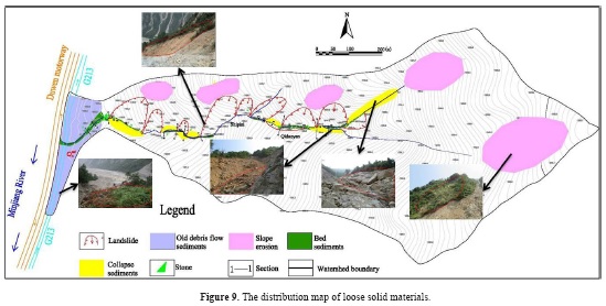
The Wenchuan earthquake of May 12, 2008 produced a great deal of loose solid material that can lead to the development of devastating debris flows (Tang et al. 2009, 2011). Shieh et al (2009) pointed out that the loose sediments, deposited by the co-seismic landslides, were the main reason for a lowering of the meteorological thresholds for debris flows. The debris flow activity in these earthquake-affected areas is very high in the first 510 years after an earthquake, while the total period with an increased potential for debris flow activity can last 20 to 40 years (Tang et al. 2012). The distribution of loose solid materials in Lianshan Bridge debris flow gully was mapped through post-disaster field investigations and remote sensing interpretation (Figure 8). Pit tests were used to determine the thickness of solid materials, and the total volume of loose solid materials was calculated through field measurements. Radar mapping was used to determine the thickness of the solid materials in some areas of the gully bed where pit tests were difficult to undertake, and the volume of solid materials calculated (Figure 9). The area and thickness of old debris flow deposits and landslide deposits were obtained by remote sensing, which measured the area of colluvial deposits; the function (Guzzetti et al. 2008) was used to calculate the volume of the colluvial deposits. The loose solid material in the Lianshan Bridge debris flow gully was 140.5×10⁴ m3 based on the field investigation and remote sensing interpretation, including collapse sediments 197,000 m3, landslide 721,000 m3, bed sediments 57,000m3, slope erosion loose solid materials 325,000 m3, old debris flow sediments 105,000m3. Such abundant loose solid material provided source conditions for the large-scale debris flow outbreak.

4.3 Deposition characteristics
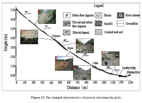
4.3.1 The characteristics of particle size along the gully
The gully is divided into 6 parts based on the changes in the particle size characteristics (Figure 10). These are: (a) From the top of gully to Qidaoyan, the particle size is mostly gravel-cobble, containing angular diorite and granite, without sorting. The gravel size is generally in the 3-10cm range, and the gravel content is 40-50%. The stone size is generally 20-40cm, and the content is about 30%. The largest stone size is up to 3m. (b) From the right branch ditch to the entrance of the main gully, the particle distribution is mostly stone, containing angular diorite and granite, without sorting. The gravel size is generally in the 5-15cm range, and the gravel content is 30-40%. The sizes of the stones are generally in the 30-60cm range, and the stone content is approximately 40%, with the largest stone size up to 2.5m. (c) From Qidaoyan to Shipizi, the particles are mostly stone and soil; the stone is angular diorite and granite, without sorting. The gravel size is 6-16cm, and the gravel content is 20-30%. The stone size is generally in the 20-60cm range, and the stone content is about 50%. The largest stones are up to 2m. (d) In the Shipizi gully, the characteristic particle size shows mostly gravel and soil, containing angular diorite and granite, without sorting. The gravel size is generally 5-15cm, and the gravel content is 40-50%. The stone size is mostly in the 20-40cm range, and the content of stone is about 25%; the stone size can be up to 4m. (e) From Shipizi to an altitude of 1100m, the particles are mostly gravel and soil; the gravel is angular diorite and granite, without sorting. The gravel size is 5-20cm, and the content is 30-40%. The stone size is in the 20-60cm range, and the stone content makes up about 20%, with the largest stones up to 2m. (f) From an altitude 1100m to the mouth of gully, the particles are mostly gravel and soil; the gravel is angular diorite and granite, without sorting. The gravel size is generally in the 5-15cm range making up 10-15% of the whole. The stone size is mostly 20-60cm, and the stone content is about 5%; the largest stones can be up to 1.5m.
4.3.2 The particle characteristics on debris flow deposition
The debris flow partition accumulation characteristic of the gully is significant because of the gradient of the gully. The debris flow deposition is mainly distributed on the lower slopes and wider regions of gully downstream. From the field investigation, it was found that the composition of the material has a wide grading of soil, and the clay fraction is less. The majority of the stone is angular, and the stone content is about 50-60%. Lithology varies between mostly anorthosite and granodiorite (Table 12).

5. The block and burst characteristics of a debris flow gully
It is unusual that such a large-scale debris flow outbreak should occur in such a small debris flow gully. Blockage of debris flow gully is the main reason for large-scale debris flow outbreaks in small debris flow gullies in earthquake-affected areas. In Lianshan Bridge debris flow discharge case, it was found that there were two discharge alteration points, in section No. 2 to No. 3 (the discharge increased from 33.6m3/s to 62.4m3/s, an increase of nearly 100%) and in section No. 4 to No. 5, where the discharge increased from 73.2m3/s to 157.8m3/s, a discharge increase of over 100% (Figure 11).

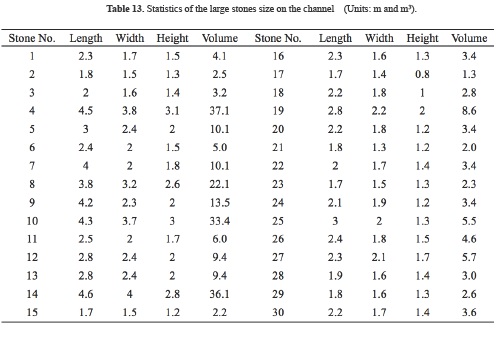
Site investigations make it apparent that large stones (greater than 1.5m in length) in the Lianshan Bridge channel were considered to have a statistical effect on the debris flow discharge (Table 13). Because the shape of large stone is irregular, the volume of stone is calculated based on the cuboids, and multiplied by the experiential coefficient 0.7 for China's western mountains (Hu et al.2011; Chen et al. 2005). The channel distribution of these large stones is shown in Figure 9 and 11. The main reason for the change in debris flow discharge is these large landslides and massive stones. Two sections 3 and 5 block the movement of debris flow. Because of higher hydraulic gradient and strong impact of landslide around this section, it offers more resistance as compared to section 3 (Figure 11 and 12).

6. Prevention and control measures
Strong earthquakes often induce a large number of collapses, landslides and unstable slopes and also generate abundant unconsolidated material that contributes to debris flow. Debris flows will be a major hazard in the Wenchuan earthquake area for many years (Cui et al. 2014). Characteristics of debris flow in the Wenchuan earthquake area compel us to take engineering measures before the active period of debris flows. New engineering structures are proposed in this paper to mitigate debris flow hazards along some small gullies and slopes. The appropriate engineering measures include the buildup of one or more block dams, to stop the huge stones, and a fence wall to resist the loose solid materials to reach on the outside of gully. A block dam engineering measure has already been applied in the circulation area of debris flow which makes the steady flow of the loose solid materials. One horizontal grilled dam was built in the accumulation area to intercept large stones. The debris flow will then be channeled into a drainage groove, and finally drained into the Minjiang River (Figure 12).
7. Summary
After the Wenchuan earthquake, debris flows from Yinxing to Miansi Town in Wenchuan County along the G213 road occurred often, resulting in frequent interruption of traffic on both the G213 road and Duwen highway. Using field investigations, remote sensing interpretation, laboratory experiments, model calculation and interviewing local residents, it was concluded that the factors influencing the debris flow were the formation processes and dynamic characteristics of “7.10” Lianshan Bridge debris flow. The following conclusions were drawn from the available information. (a) In areas with long term seismic activity, intense rainfall can easily induce debris flow. (b) Bank collapse and large rocks also contributed to an increase in debris flow scale and discharge, and eventually led to the “7.10” large scale debris flow in the Lianshan Bridge gully watershed. (c) Currently, there is still considerable loose solid material available for debris flow formation in these gullies. Landslide deposition, channel deposition, and soil erosion sediment are three kinds of sediment that supply material for debris flow formation. The total volume of loose solid material is 140.5× 10⁴ m3. Such large amounts of solid loose sediment could generate debris flows easily given adequate rainfall. (d) Reliable prevention and control measures should be put forward with the purpose of reducing debris flow disasters in these debris flow gullies (e) Monitoring and early warning systems should be set up and government should strengthen propaganda on disaster prevention and mitigation to improve residents' consciousness of debris flow disasters, which could effectively reduce the human and infrastructure losses caused by debris flow hazards.
Acknowledgements
This research was supported by the National Natural Science Foundation of China (Grant No. 41501012 and 41661134012) and Foundation for selected young scientists, Institute of Mountain Hazards and Environment, CAS (No.SDS-QN-1306, Y3L1340340, sds-135-1202-02).
References
Chen, H.X., Zhang, L.M., Chang, D.S., and Zhang, S. (2012). Mechanisms and runout characteristics of the rainfall-triggered debris flow in Xiaojiagou in Sichuan Province, China, Nat. Hazards. 62 (3), 1037-1057.
Chen, H.X., Zhang, L.M., Zhang, S., Xiang, B., and Wang, X.F. (2013). Hybrid simulation of the initiation and runout characteristics of a catastrophic debris flow, Journal of Mountain Science. 10 (2), 219-232.
Chen, N.S., Cui, P., Liu, Zh.G., and Wei, F.Q. (2003). Calculation of the debris flow concentration based on clay content, Science in China Ser. E Technological Sciences. 46, 163-174.
Chen, N.S., Li, T. Ch., Gao, Y. Ch. (2005) . A great disastrous debris flow on 11 July 2003 in Shuikazi valley, Danba County, western Sichuan, China, Landslides. 2:71-74.
Chen, N.S., Hu, G.S., Deng, M.F., Zhou, W., Yang, C.L., Han, D., and Deng, J.H. (2011a). Impact of earthquake on debris flows-a case study on the Wenchuan earthquake, J. Earthq.Tsunami. 5 (5), 493-508.
Chen, N.S., Yang, C.L., Zhou, W., Hu, G.S, Li, H., and Han, D. (2009). The critical rainfall characteristics for torrents and debris flows in the Wenchuan earthquake stricken area, Journal of Mountain Science. 6, 362-372.
Chen, N.S., Yang, C.L., Zhou, W., Wei, F.Q., Li, Z.L., Han, D., and Hu, G.S. (2011b). A new total volume model of debris flows with intermittent surges: based on the observations at Jiangjia Valley, southwest China, Nat Hazards. 56, 37-57.
Cui, P., Hu, K.H., Zhuang, J.Q., Yang, Y., and Zhang, J.Q. (2011). Prediction of debris-flow danger area by combining hydrological and inundation simulation methods. Journal of Mountain Science. 8, 1-9.
Guzzetti, F., Peruccacci, S., Rossi, M., and Stark, C.P. (2008). The rainfall intensity-duration control of shallow landslides and debris flows: an update, Landslides. 5(1), 3-17.
He, S.M., Wu, Y., and Shen, J. (2009). Simplified calculation of impact force massive stone in debris flow, Journal of natural disasters. 18(5), 51-56 (in Chinese with English abstract).
Hu, G.S., Chen, N.S., Deng, M.F and Lu, Y. (2011). Analysis of the characteristics of impact force of massive stones of Sanyanyu debris flow gully in Zhouqu, Gansu province, Earth and Environment. 39(4), 478-484 (in Chinese with English abstract).
Huang, R., Pei, X., and Fan, X. (2012). The characteristics and failure mechanism of the largest landslide triggered by the Wenchuan earthquake, May 12, 2008, China, Landslides. 9, 131-142.
Liu, J.F., You, Y., and Chen, X.C. (2010). Identification of potential sites of debris flows in the upper Min river drainage, following environmental changes caused by the Wenchuan earthquake, Journal of Mountain Science. 7, 255-263.
Ni, H., Zheng, W., Tie, Y., Su, P., Tang, Y., Xu, R., Wang, D., and Chen, X. (2012). Formation and characteristics of post-earthquake debris flow: a case study from Wenjia gully in Mianzhu, Sichuan, China, Natural Hazards. 61 (2), 317-335.
Shieh, C.L., Chen, Y.S., Tsai, Y.J., and Wu, J.H. (2009). Variability in rainfall threshold for debris flow after the Chi-Chi earthquake in central Taiwan, China, Int. J. Sediment Res. 24, 177-188.
Tang, C., Zhu, J., Li, W., and Liang, J. (2009). Rainfall-triggered debris flows following the Wenchuan earthquake, Bulletin of Engineering Geology and the Environment. 68 (2), 187-194.
Tang, C., Zhu, J., and Ding, J. (2011). Catastrophic debris flows triggered by a 14 August 2010 rainfall at the epicentre of the Wenchuan earthquake, Landslides. 8, 485-497.
Tang, C., Van, A.T., Chang, M., Chen, G., Zhao, X., and Huang, X. (2012). Catastrophic debris flows on 13 August 2010 in the Qingping area, southwestern China: The combined effects of a strong earthquake and subsequent rainstorms, Geomorphology. 139, 559-576.
Wang, J.J., Zhao, D., Liang, Y., and Wen, H.B. (2013). Angle of repose of landslide debris deposits induced by 2008 Sichuan Earthquake, Engineering Geology. 156, 103-110.
Wang, Z.Y., Qi, L.J., and Wang, X.Z. (2012). A prototype experiment of debris flow control with energy dissipation structures, Nat. Hazards. 60, 971-989.
Xu, Q., Zhang, S., Li, W.L., Van A.T., and Tan, W.J. (2012). The 13 August 2010 catastrophic debris flows after the 2008 Wenchuan earthquake, China, Nat. Hazards Earth Syst. Sci. 12, 201-216.
You, Y., Liu, J.F., and Chen, X.C. (2012). Design of Sluiceway channel in a landslide dam triggered by the Wenchuan earthquake, Disaster Adv. 5, 241-249.
Yu, B., Wu, Y.F., and Chu, Sh.M. (2014). Preliminary study of the effect of earthquakes on the rainfall threshold of debris flows, Engineering Geology. 182, 130-135.
Zhang, H.P., Yang, N., and Zhang, Y.Q. (2006). Geomorphology of the Minjiang drainage system (Sichuan, China) and its structural implications, Quat. Sci. 26, 126-135 (in Chinese with English abstract).
Zhang, S., Zhang, L.M., Chen, H.X., Yuan, Q., and Pan, H. (2013). Changes in runout distances of debris flows over time in the Wenchuan earthquake zone. Journal of Mountain Science. 10 (2), 281-292.
Zhou, R.J., Pu, X.H., and He, Y.L. (2000). Recent activity of Minjiang fault zone, uplift of Minshan block and their relationship with seismicity of Sichuan, Seismol. Geol. 22, 285-294 (in Chinese with English abstract).
References
Chen, H. X., Zhang, L. M., Chang, D. S. & Zhang, S. (2012). Mechanisms and runout characteristics of the rainfall-triggered debris flow in Xiaojiagou in Sichuan Province, China. Natural Hazards, 62 (3), 1037–1057.
Chen, H. X., Zhang, L. M., Zhang, S., Xiang, B., & Wang, X. F. (2013). Hybrid simulation of the initiation and runout characteristics of a catastrophic debris flow. Journal of Mountain Science, 10(2), 219–232.
Chen, N. S., Cui, P., Liu, Z. G., & Wei, F. Q. (2003). Calculation of the debris flow concentration based on clay content. Science in China Ser. E Technological Sciences, 46, 163-174.
Chen, N. S., Li, T. C., & Gao, Y. C. (2005). A great disastrous debris flow on 11 July 2003 in Shuikazi valley, Danba County, western Sichuan, China. Landslides, 2, 71–74.
Chen, N. S., Hu, G. S., Deng, M. F., Zhou, W., Yang, C. L., Han, D., & Deng, J. H. (2011a). Impact of earthquake on debris flows-a case study on the Wenchuan earthquake. J. Earthq.Tsunami, 5 (5), 493–508.
Chen, N. S., Yang, C. L., Zhou, W., Hu, G. S, Li, H., & Han, D. (2009). The critical rainfall characteristics for torrents and debris flows in the Wenchuan earthquake stricken area. Journal of Mountain Science, 6, 362–372.
Chen, N. S., Yang, C. L., Zhou, W., Wei, F. Q., Li, Z. L., Han, D., & Hu, G. S. (2011b). A new total volume model of debris flows with intermittent surges: based on the observations at Jiangjia Valley, southwest China. Nat Hazards, 56, 37–57.
Cui, P., Hu, K. H., Zhuang, J. Q., Yang, Y., & Zhang, J. Q. (2011). Prediction of debris-flow danger area by combining hydrological and inundation simulation methods. Journal of Mountain Science, 8, 1–9.
Guzzetti, F., Peruccacci, S., Rossi, M., & Stark, C.P. (2008). The rainfall intensity–duration control of shallow landslides and debris flows: an update. Landslides, 5(1), 3-17.
He, S. M., Wu, Y., & Shen, J. (2009). Simplified calculation of impact force massive stone in debris flow (in Chinese with English abstract). Journal of natural disasters, 18(5), 51-56
Hu, G. S., Chen, N. S., Deng, M. F and Lu, Y. (2011). Analysis of the characteristics of impact force of massive stones of Sanyanyu debris ow gully in Zhouqu, Gansu province (in Chinese with English abstract). Earth and Environment, 39(4), 478-484.
Huang, R., Pei, X., & Fan, X. (2012). The characteristics and failure mechanism of the largest landslide triggered by the Wenchuan earthquake, May 12, 2008, China. Landslides, 9, 131–142.
Liu, J. F., You, Y., & Chen, X. C. (2010). Identification of potential sites of debris flows in the upper Min river drainage, following environmental changes caused by the Wenchuan earthquake. Journal of Mountain Science, 7, 255–263.
Ni, H., Zheng, W., Tie, Y., Su, P., Tang, Y., Xu, R., Wang, D., & Chen, X. (2012). Formation and characteristics of post-earthquake debris flow: a case study from Wenjia gully in Mianzhu, Sichuan, China, Natural Hazards. 61 (2), 317-335.
Shieh, C. L., Chen, Y. S., Tsai, Y. J., & Wu, J. H. (2009). Variability in rainfall threshold for debris flow after the Chi-Chi earthquake in central Taiwan, China. Int. J. Sediment Res. 24, 177–188.
Tang, C., Zhu, J., Li, W., and Liang, J. (2009). Rainfall-triggered debris flows following the Wenchuan earthquake, Bulletin of Engineering Geology and the Environment. 68 (2), 187-194.
Tang, C., Zhu, J., and Ding, J. (2011). Catastrophic debris flows triggered by a 14 August 2010 rainfall at the epicentre of the Wenchuan earthquake. Landslides, 8, 485–497.
Tang, C., Van, A. T., Chang, M., Chen, G., Zhao, X., & Huang, X. (2012). Catastrophic debris flows on 13 August 2010 in the Qingping area, southwestern China: The combined effects of a strong earthquake and subsequent rainstorms. Geomorphology, 139, 559-576.
Wang, J. J., Zhao, D., Liang, Y., & Wen, H. B. (2013). Angle of repose of landslide debris deposits induced by 2008 Sichuan Earthquake. Engineering Geology, 156, 103–110.
Wang, Z. Y., Qi, L. J., & Wang, X. Z. (2012). A prototype experiment of debris flow control with energy dissipation structures. Natiural Hazards, 60, 971–989.
Xu, Q., Zhang, S., Li, W. L., Van, A. T., & Tan, W. J. (2012). The 13 August 2010 catastrophic debris flows after the 2008 Wenchuan earthquake, China. Nat. Hazards Earth Syst. Sci., 12, 201–216.
You, Y., Liu, J. F., & Chen, X. C. (2012). Design of Sluiceway channel in a landslide dam triggered by the Wenchuan earthquake. Disaster Adv., 5, 241–249.
Yu, B., Wu, Y. F., & Chu, S. M. (2014). Preliminary study of the effect of earthquakes on the rainfall threshold of debris flows. Engineering Geology, 182, 130–135.
Zhang, H. P., Yang, N., & Zhang, Y. Q. (2006). Geomorphology of the Minjiang drainage system (Sichuan, China) and its structural implications, Quat. Sci. 26, 126–135 (in Chinese with English abstract).
Zhang, S., Zhang, L. M., Chen, H. X., Yuan, Q., & Pan, H. (2013). Changes in runout distances of debris flows over time in the Wenchuan earthquake zone. Journal of Mountain Science, 10(2), 281–292.
Zhou, R. J., Pu, X. H., & He, Y. L. (2000). Recent activity of Minjiang fault zone, uplift of Minshan block and their relationship with seismicity of Sichuan. Seismol. Geol., 22, 285–294 (in Chinese with English abstract).
How to Cite
APA
ACM
ACS
ABNT
Chicago
Harvard
IEEE
MLA
Turabian
Vancouver
Download Citation
CrossRef Cited-by
1. Sadegh Rezaei, Issa Shooshpasha, Hamed Rezaei. (2018). Empirical Correlation between Geotechnical and Geophysical Parameters in a Landslide Zone (Case Study: Nargeschal Landslide). Earth Sciences Research Journal, 22(3), p.195. https://doi.org/10.15446/esrj.v22n3.69491.
2. Xianzheng Zhang, Chenxiao Tang, Ning Li, Jiang Xiong, Ming Chen, Mingwei Li, Chuan Tang. (2022). Investigation of the 2019 Wenchuan County debris flow disaster suggests nonuniform spatial and temporal post-seismic debris flow evolution patterns. Landslides, 19(8), p.1935. https://doi.org/10.1007/s10346-022-01896-6.
3. Kun He, Yongjian Li, Guotao Ma, Xiewen Hu, Bo Liu, Zhigang Ma, Zepeng Xu. (2021). Failure mode analysis of post-seismic rockfall in shattered mountains exemplified by detailed investigation and numerical modelling. Landslides, 18(1), p.425. https://doi.org/10.1007/s10346-020-01532-1.
4. Mei Liu, Yong Zhang, Shu-feng Tian, Ning-sheng Chen, Rahman Mahfuzr, Iqbal Javed. (2020). Effects of loose deposits on debris flow processes in the Aizi Valley, southwest China. Journal of Mountain Science, 17(1), p.156. https://doi.org/10.1007/s11629-019-5388-9.
Dimensions
PlumX
Article abstract page views
Downloads
License
Earth Sciences Research Journal holds a Creative Commons Attribution license.
You are free to:
Share — copy and redistribute the material in any medium or format
Adapt — remix, transform, and build upon the material for any purpose, even commercially.
The licensor cannot revoke these freedoms as long as you follow the license terms.


