


Published
Geological and geophysical evaluation of the Ajana area’s groundwater potential, southwestern Nigeria
clayey-sandy, fractured / weathered basement and fresh bedrock were delineated. The aquifer layers were the 38.3m thick 283 ?m resistivity sand/sandy clay and 55 - 518 ?m resistivity fractured/weathered basement. Other geoelectric parameters used in evaluating the area's hydrogeological potential included curve type, anisotropy coefficient and reflection coefficient - The QH curve type was predominant in the area. The anisotropy Coefficients suggested VES stations having high groundwater potential ranging from 1.4 - 1.56; while the reflection coefficients for the area ranged from 0.21 - 0.99. The overall results showed that VES stations 8, 9 and 10 could be possible groundwater sources having high expected yield.
Geological and geophysical evaluation of the Ajana area's groundwater potential, southwestern Nigeria
Ariyo, Stephen O.1; Folorunso, Adetayo F.2; Ajibade O.M.3
1 Department of Earth Sciences, Olabisi Onabanjo University, Ago-Iwoye, Nigeria E-mail: ariyof@yahoo.com
2 Department of Geosciences, University of Lagos, Lagos, Nigeria E-mail: detayf@yahoo.com;
3 Department of Earth Sciences, Olabisi Onabanjo University, Ago-Iwoye, Nigeria E-mail: ajibademuyiwa@yaoo.com Corresponding E-mail: detayof@yahoo.com
Record
Manuscript received: 20/11/2010 Accepted for publication: 31/05/2011
ABSTRACT
A combined geological and geophysical evaluation was made of the ground water potential of the Ajana, Remo Northarea in south-western Nigeria; the geology and other structural features of the rocks there strongly influenced and correlated the aquifers' storability and transmissivity. Geological mapping revealed that the area was made up of granite, quartzite and varieties of gneiss, some of which have good secondary porosity and permeability. Ten vertical electric soundings (VES) stations were established using a Schlumberger electrode array. Five geoelectric layers consisting of topsoil, sand, clayey-sandy, fractured / weathered basement and fresh bedrock were delineated. The aquifer layers were the 38.3m thick 283 ?m resistivity sand/sandy clay and 55 - 518 ?m resistivity fractured/weathered basement. Other geoelectric parameters used in evaluating the area's hydrogeological potential included curve type, anisotropy coefficient and reflection coefficient - The QH curve type was predominant in the area. The anisotropy Coefficients suggested VES stations having high groundwater potential ranging from 1.4 - 1.56; while the reflection coefficients for the area ranged from 0.21 - 0.99. The overall results showed that VES stations 8,9 and 10 could be possible groundwater sources having high expected yield.
Keywords: Reflection Coefficient, Anisotropy Coefficient, Geoelectric Layers, Groundwater Potential, Mapping, Ajana
RESUMEN
Se realizó una evaluación geológica - geofísica del potencial hidrogeológico en Ajana, Remo North en la zona suroeste de Nigeria; la geología y las fracturas en las rocas están estrechamente relacionadas con la capacidad de almacenamiento y transmisividad de los acuíferos. El mapeo geológico revela que el área está conformada por granitos, cuarcitas y variedades de gneis, algunos con buena porosidad secundaria y permeabilidad. Se realizaron diez Sondeos Eléctricos Verticales (SEV) en configuración Schlumberger, donde se establecieron cinco capas: Suelo, arena, arcilla arenosa, basamento fracturado -meteorizado y roca fresca. Las capas acuíferas tiene espesores de 38.2m con resistividades de 283 Ùm para arenay arcilla arenosa, y resistividades entre 55-518 Ùm para el basamento meteorizado. Otros parámetros geoeléctricos utilizados en la evaluación del potencial hidrogeológico de la zona incluyen el tipo de curva, el coeficiente de anisotropía y el coeficiente de reflexión - Las curvas tipo QH fueron predominantes en la zona. Los coeficientes de anisotropía sugirieren que los SEV tienen gran potencial hidrogeológico con un rango de 1.40 a 1.56; mientras que los coeficientes de reflexión para la zona variaron entre 0,21 y 0,99. Los resultados generales mostraron que en los puntos de los SEV 8,9 y 10 podrían ser posibles fuentes de agua subterránea con alto rendimiento.
Palabras clave: Coeficiente reflexión, coeficiente anisotropía, capas geoeléctricos, potencial Hidrológico, mapeo, Ajana
Introduction
Groundwater is a vital natural resource for providing a community's water supply and plays a fundamental role in human well-being, as well as that of many aquatic ecosystems. It is a preferred water source in many instances because water quality is generally good as it has been filtered by the soil, it is readily available and is often the only source of freshwater available due to its better spatial extension and distribution. There is constantly increasing demand for this resource which has resulted in the tremendous development of groundwater resources during recent years. Unfortunately, it is not readily available like surface water and its exploitation involves costs and demands a form of technical-know-how.
The early 1900's brought about the development of the electrical resistivity method in deciphering ground water potential. Since then,improved technologies have led to a more refined approach to the exploration and exploitation of groundwater resources. Applying the resistivity method with the availability of computers for processing and analysing data has greatly helped the matter (Reynoids, 1997). Many researchers such as Ako et al, (1986), Agwunobi and Onuoha (1998), Olorunfemi and Olorunniwo, (1985), and Ariyo, (2003) have successfully located prolific boreholes using this method.
Physiographic setting
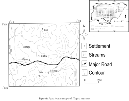
The study area lies between latitudes 7o 03'N and 7o 05'N and longitudes 3o43'E and 3o 46'E, covering an area of around 20km2. It falls within Nigeria's tropical rain forest belt. The relief is low with elevation above sea level ranging between 16.1 - 117m. The major river draining the area is the River Ona which flows souther, having tributaries forming a dendritic drainage pattern. Figure 1
The area's geology
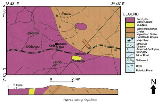
The Ajana area falls within south-western Nigeria's Precambrian Basement Complex rocks. The Basement Complex accounts for about 80% of south-western Nigeria's total surface. South-western Nigeria's basement complex rocks have been classified into migmatite-gneiss complexes, meta-sedimentary and meta- volcanic rocks (the schist belts), the Pan-African granitoids (the older granites) and undeformed acid and basic dykes (Rahama, 2006). The study area's geology consisted migmatised biotite - hornblende gneiss, biotite - hornblende gneiss, quartzite and granite.
Data acquisition
Geological mapping
Rock samples were taken from rock outcrops throughout the area. Samples fell into four different rock types: migmatised biotite-hornblende gneiss occupying the study area's north-eastern part, biotite-hornblende gneiss (a flat-lying outcrop found in one location), quartzite and granite occupying the largest part of the study area. Petrographic studies of the rocks revealed a plethora of minerals including biotite, hornblende, quartz, muscovite, microcline and plagioclase feldspar and some accessory minerals, Figure 2.
The Geoelectric Survey
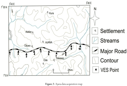
Ten Vertical Electrical Soundings (VES) were made in the area using Schlumberger electrode array (Figure 3). Earth resistance measurements were made with a Syscal Junior Terrameter (a high-powered, fully-automatic resistivity meter for DC electrical surveys); it has been used over the years for groundwater exploration, environmental studies, civil engineering and structural geology investigation. It has the advantage of directly measuring ground material's apparent resistivity as against earlier instruments which measured earth resistance to obtain the ground's resistivity.
Apparent ground resistivity was obtained; ground resistivity was calculated by multiplying by appropriate geoelectric constants. The results were plotted on a log-log graph scale, a sample of which is shown in Figure 4.
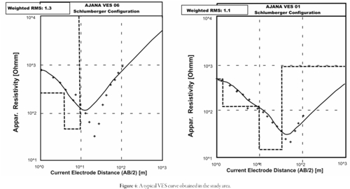
Partial curve matching techniques using two-layer model curves and corresponding auxiliary curves were used to arrive at curve types.
WINREST software was used in this survey to determine appropriate resistivity values. The field curves were compared with the computer-generated curves and a good fit was obtained as shown in Figure 4. Table 1 shows the computer modelling results for the sounding stations and the corresponding depths.
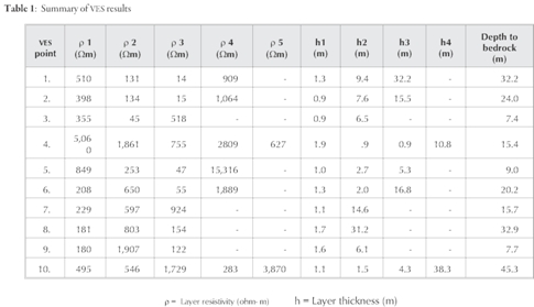
The table shows that three to five geoelectric layers were delineated as follows:
The first layer was topsoil consisting of 0.9m- 1.9m thickness 180-5,060 Ωm resistivity sand/sandy clay and laterite;
The second layer consisted of 0.9m thick clay layer having 45 Ωm resistivity and 0.9 - 31.2m thick and 131 - 803 Ωm resistivity sand/sandy clay layer.
The third layer was a 5.3 - 32.2 m thick 14-47 Ωm resistivity clay layer and sandy layer having 755 Ωm resistivity and 0.9 m thickness, weathered layer having 55 Ωm resistivity and 16.5m thickness and 122 - 518 Ωm resistivity fractured rock, and a 924 Ωm fresh basement.
The fourth layer was composed of 38.3m thick 283 Ωm resistivity sand and fresh rock having 909- 1,5316 Ωm with 9- 32.2m depth to basement.
The fifth layer is made up of 627 Ωm resistivity fractured rock and fresh basement having 3870 Ωm resistivity and 45.3m depth to basement.
The fractured/weathered basement constituted the major aquifer in the area based on their thick over burden and relatively low resistivity values. Thus, VES points 3, 4, 6 and 8-10 having 55-518 Ωm resistivity and 7.4 - 45.3m overburden thicknesses respectively could be a good area for groundwater exploration.
VES 3, 6, 8, 9 and 10 had good aquifer quality (layer resistivity and thickness), being favourable for groundwater exploitation based on the geoelectric layers so delineated. VES station 3 consisted of fractured rock but the expected water depth in the borehole was too small to recommend it for borehole drilling (meaningthat it was left offthe list).
Curve Types
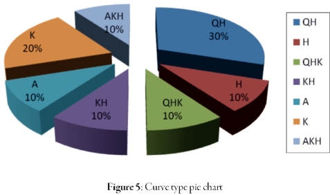
Curve matching depicted four layer curves (QH, KH) at four VES stations, three layer curves (H, A, and K types) at four VES stations and five layer curves (QHK AKH)attwo VES stations (Table 2).
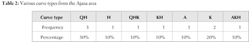
Table 2 shows that the QH curve type predominated in the study area. Ariyo (2003) proposed that the QH curve type is generally characterised by high groundwater provided that the aquifer unit is appreciably thick. However, VES points 1, 2 and 5 having QH curve types were clayey aquifers (aquitard) which would have poor groundwater yield.
Geoelectric parameters
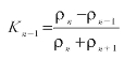
The geoelectric layers derived from electrical sounding were described by two basic parameters - layers resistivity and thickness. Other geoelectric parameters were derived from the fundamental parameters mentioned above (Zohdy et al, 1974), such as anisotropy coefficient (λ) and reflection coefficient. They were mathematically derived as:
Anisotropy coefficient
The overburden anisotropy coefficient was given as


where ρC = transverse resistivity in Ωm.

ρ L = longitudinal resistivity in Ωm

where hi = layer thickness in m ρi = layer resistivity in m
Anisotropy coefficients were calculated from the layer resistivity and thickness obtained from qualitative interpretation raging from 1.03 - 1.82. Whereas, a range of 1.39 - 1.66 anisotropy coefficient has been judged necessary for boreholes to be considered productive in some parts of south-western Nigeria's basement complex (Olorunfemi and Olorunniwo, 1985). Groundwater yield increases with anisotropy coefficient (Olorunfemi et. al., 1991), although VES 5,6 and 9 had good anisotropy coefficients of 1.4 -1.66, only VES 6 had appreciable aquifer thickness (16.8m).
Reflection coefficient
The bedrock interface reflection coefficient is an important parameter which shows that a bedrock fracture is filled with water. There must be a direct correlation with the anisotropy coefficient value for this parameter to be considered. However, the present study showed that intermediate reflection coefficient values correlated with sand aquifer were expected to be prolific if developed into a borehole. It was also noticed that reflection and anisotropy coefficients for VES points 8,9 and 10 had a linear relationship, thus, the parameter could be considered (together with other parameters) as being good factor in selecting a site for developing borehole. This was given as:
where ρn = bedrock resistivity
ρn-1 = sub-basement resistivity
Conclusion
This paper has reported a geological and geophysical evaluation of Ajana's groundwater. The area's geology delineated from geological mapping showed that it consisted of granite, quartzite and varieties of gneiss. Rock type has a direct influence on an area groundwater, as easily fractured rock like quartzite, would enhance secondary porosity and permeability while hard and resistant rock like basalt would adversely affect aquifer parameters. VES data was also acquired and interpreted using WINREST software to determine the primary geoelectric parameters from which further geoelectric parameters were derived. Based on layer thickness and resistivity values, VES 6,8,9 and 10 located on a weathered (VES 6) andsandy layer (VES 8 to 10) have been recommended. However, only VES 8 to 10 had low to medium reflection coefficients having a linear relationship with their overburden anisotropy coefficients. VES stations 8 to 10 had good aquifer thicknesses meaning that if developed into water boreholes, the water column would be thick enough to sustain the local people's water need (i.e. VES stations 8,9 or 10 could be drilled and developed into producing water boreholes).
References
Agwunobi, O.E., and Onuoh, K.M. (1988): Geophysical investigation for groundwater in hardrock terrains: Experiences from the Fobour Area of the Jos-Plateau, Nigeria. Journal of Mining and Geol., Vol. pp. 45 - 50.
Ako, B.D., Adegoke, O.S., Ajayi, T.R., Ajayi, J.O., and Rahaman, M.A., (1986): Groundwater prospecting and exploitation in Nigeria; in proceedings of the first annual symposium and exhibition on groundwater resources in Nigeria, NIWASA, Lagos, Nigeria, pp. 3-4.
Ariyo, S.O. (2003): Geophysical Investigation of the groundwater potential of Iseyin. Journals of Applied Sciences, Vol. 6, No. 1,pp. 3393-3402.
Keller, G.V and Frischknecht, F.C. (1966). Electrical methods in geological prospecting. Pergamon Press. New York, Pp33-37.
Olorunfemi, M.O. Olanrewaju, V.O. and Alade, O., (1991): On electrical anisotropy and ground water yield in a basement complex area south-western Nigeria. Journal ofAfrica Earth Sciences, Vol. 12, No. 93, pp. 247-327.
Olorunfemi M.O. and Olorunnwo, M.A. (1985): Geoelectric parameters and aquifers characteristics of some parts of south-western Nigeria. Geological Application Indiogeologic, Vol. 20, pp. 99 - 109.
Rahaman, M.A., (2006): Nigeria's solid minerals Endowment and sustainable development in the basement complex of Nigeria and its mineral resources,edited by Oshin. A kin Jinad & Co., Ibadan,Nig. Pp. 139- 168.
Reynoids, J.M. (1997): An introduction to applied and environmental geophysics. John Wiley & Sons. New York, pp. 417-490.
Zohdy, A.A.R., Eaton, G.P. andMabey, D.R. (1974): Application of surface geophysics to groundwater investigations: in Tech. of Water Sources Investigations of the U.S. Geol. Survey, Book 2, Chap, Dl.
How to Cite
APA
ACM
ACS
ABNT
Chicago
Harvard
IEEE
MLA
Turabian
Vancouver
Download Citation
Article abstract page views
Downloads
License
Earth Sciences Research Journal holds a Creative Commons Attribution license.
You are free to:
Share — copy and redistribute the material in any medium or format
Adapt — remix, transform, and build upon the material for any purpose, even commercially.
The licensor cannot revoke these freedoms as long as you follow the license terms.
The Earth Sciences Research Journal is the copyright holder for these license attributes.


