


Published
RADIOGENIC COMPONENTS OF THE NIGERIAN TAR SAND DEPOSITS
THE MAXIMUM EFFECT OF DEEP LAKES ON TEMPERATURE PROFILES -DETERMINATION OF THE GEOTHERMAL GRADIENT
V.T. Balobaev1, I. M. Kutasov2 and L. V. Eppelbaum3
1Permafrost Institute, Siberian Branch of the Russian Academy of Sciences, Yakutsk 677018, Russia
2Pajarito Enterprises, 640 Alta Vista, Suite '24, Santa Fe, New Mexico 87505, USA
3Dept. of Geophysics and Planetary Sciences, Raymond and Beverly Sackler Faculty of Exact Sciences, Tel Aviv University, Ramat Aviv 69978, Tel Aviv, Israel
Corresponding author, E-mail: levap@post.tau.ac.il; Fax: +972 3 6409282
Manuscript received: January 01 , 2009. Accepted for publication: February 27th, 2009.
ABSTRACT
Understanding the climate change processes on the basis of geothermal observations in boreholes is an important and at the same time high-intricate problem. Many non-climatic effects could cause changes in ground surface temperatures. In this study we investigate the effects of deep lakes on the borehole temperature profiles observed within or in the vicinity of the lakes. We propose a method based on utilization of Laplace equation with nonuniform boundary conditions. The proposed method makes possible to estimate the maximum effect of deep lakes (here the term "deep lake" means that long term mean annual temperature of bottom sediments canbe considered as a constant value) on the borehole temperature profiles. This method also allows one to estimate an accuracy of the determination of the geothermal gradient.
Key words: Geothermal gradient, Reduced temperature, Laplace equation, Lake
RESUMEN
El entendimiento de los procesos de cambio climático basado en las observaciones geotérmicas en pozos es importante y a la vez un problema intrincadamente complejo. Muchos efectos no climáticos podrían causar cambios en las temperaturas de la superficie terrestre. En este estudio investigamos el efecto de los lagos profundos sobre los perfiles de temperatura registrados en pozos, al interior o en las inmediaciones de los lagos. Proponemos un método basado en el uso de la ecuación de Laplace con condiciones de frontera no uniforme. El método hace posible estimar el máximo efecto de los lagos profundos (el término "lago profundo" significa que la temperatura media anual de los sedimentos del fondo, evaluada sobre un largo período, puede ser considerada como un valor constante) sobre los perfiles de temperatura en los pozos. Este método también permite estimar la precisión en la determinación del gradiente geotérmico.
Palabras clave: gradiente Geotérmico, temperatura Reducida, ecuación Laplace, Lago.
I. Introduction
At present many efforts are made to determine the trends in ground surface temperature history (GSTH) from geothermal surveys. In this case accurate subsurface temperature measurements are needed to solve this inverse problem - estimation of the unknown time dependent ground surface temperature (GST). The variations of the GST during the long term climate changes resulted in disturbance (anomalies) of the temperature field of geological formations. Thus, the GSTH data could be evaluated by analyzing the present precise temperature-depth profiles. The effect of surface temperature variations in the past on the temperature field of formations is widely discussed in the literature (e.g., Lachenbruch and Marshall, 1986; Beltrami et al., 1992; Shen and Beck, 1992; Bodri and Cermak, 1995; Harris and Chapman, 1995; Huang etal., 1996; Guillou-Frottieretal., 1998; Huang and Pollack, 1998; Huang et al., 2000; Pollack and Huang, 2000; Majorowicz and Safanda, 2005; Eppelbaum et al., 2006; Hamza et al., 2007; Hopcroft et al., 2007; Rath and Mottaghy, 2007; Gonz'alez-Rouco et al., 2008; Kooi, 2008).
II. Previous investigations: Some research background
Earlier the forward calculation approach (FCA) was used for the analysis and interpretation of borehole temperatures in terms of the GSTH (Eppelbaum et al., 2006). Three groups based on the geographical proximity were formed. Fifteen borehole temperature profiles from Europe (5), Asia (4) and North America (6) were selected (Huang and Pollack, 1998; www.geo.lsa.umich.edu/~climate). The objective of this study was the estimation of the warming rates in the 20th century by the FCA method and comparing with those obtained by the few parameter estimation (FPE) technique (Huang et al., 1996; Huang and Pollack, 1998). It was reasonable to assume that for close spaced boreholes, the values of the warming rates obtained by the two inversion methods, should vary in narrow limits. The results of inversions (FCA) have shown that for boreholes in North America the current warming rates vary in the 0.41- 2.45 K/100a range. The wide range for the warming rate of 0.33-2.48 K/100a was also determined for boreholes in Europe. Interesting results were obtained for four boreholes in Asia (China) (Eppelbaum et al., 2006). In this case the warming rate varies in relatively narrow limits (1.16-1.59 K/100a.). The warming rate estimated by the FPE technique (Huang and Pollack, 1998) varied in wide ranges: 0.38-2.49 K/100a (North America); 0.21-3.75 K/100a (Europe), and 0.30-2.53 K/100a (Asia). Thus, we can conclude that for boreholes in North America and Europe both approaches provide practically the same ranges of warming rates. For Asian boreholes the FCA approach gives a more consistent (narrow) range of warming rates (1.16-1.59 K/100a).
The results of temperature inversion by both techniques indicate that probably some of non-climatic effects (vertical and horizontal water flows, steep topography, lakes, vertical variation in heat flow, lateral thermal conductivity contrasts, thermal conductivity anisotropy, deforestation, forest fires, mining, wetland drainage, agricultural development, urbanization, etc.) may have perturbed the borehole temperature profiles. Influence of these factors has been studying by many authors (e.g., Carslaw and Jaeger, 1959; Lachenbruch, 1965; Kappelmeyer and Haenel, 1974; Blackwell et al., 1980; Majorowicz andSkinner, 1997; Guillou-Frottieret al., 1998; Lewis and Wang, 1998; Kohl, 1999; Safanda, 1999; Pollack and Huang, 2000; Cermak and Bodri, 2001; Gosselin and Mareschal, 2003;
Gruber et al., 2004; Bodri and Cermak, 2005; Mottaghy et al., 2005; Nitoiu and Beltrami, 2005; Allen etal., 2006; Taniguchi, 2006; Chouinardand Mareschal, 2007; Hamza et al., 2007; Safanda et al., 2007). At the same time exact calculation ofall these factors is a complex physical-mathematical problem, which obviously will be completely solved in a future by the method of successive approximations.
The temperature regime of sedimentary formations is influenced by many environmental and geological factors (local relief, sedimentation, erosion, lateral conductivity contrasts, underground water movement), past climate, and by the heat flow from the Earth's interior - terrestrial heat flow. Most of temperature surveys are conducted in boreholes. In many cases the drilling sites of boreholes are located within or outside of deep lakes (we employ the term "deep lake" to designate that long term mean annual temperature of bottom sediments could be considered as a constant value). The objective of this study is to evaluate to what extent the proximity of deep lakes can affect the temperature profiles of wellbores. In 1974 Balobayev and Shastkevich published results of their analytical study which can be used to determine the configuration of the steady temperature field of formations beneath the lakes of an arbitrary contour (Balobayev and Shastkevich, 1974). Taking into account that this publication is not easily accessible to researchers, we present below a brief summation of the results of this study (Balobayev and Shastkevich, 1974). Authors assumed that the lake existed for an infinitely long period oftime. In this case the solution of Laplace equation with nonuniform boundary conditions can be used to describe the steady temperature field of formations beneath the lakes and estimate the maximum effect (due to assumption that the lake existed for an infinitely long period of time) of lakes on borehole temperature profiles.
III. Climate reconstruction methods: Some typical disturbances and restrictions
We should note that all climate reconstruction methods are based on one-dimensional heat conduction equation. It is assumed that a uniform boundary condition is applied on a plane surface, the formation is a laterally homogeneous medium, and the thermal properties can depend only on a depth. For this reasons any subsurface temperature variations arising from conditions that depart from that theoretical model have the potential to be incorrectly interpreted as a climate change signature (Pollack and Huang, 2000). To demonstrate the well selection procedures we briefly present two examples. In the study conducted by Guillou-Frottieretal. (1998), only 10from 57 temperature profiles were selected for inversion of past ground surface temperatures. As was mentioned by Nitoiu and Beltrami (2005) from over 10,000 borehole temperature logs worldwide (The International Heat Flow Commission global geothermal data set), only about 10% of these data are currently used for climate studies because a number of known non-climatic energy perturbations are superimposed on the climatic signal.
Therefore, an extreme caution should be used in selection of temperature-depth profiles for inferring the ground surface temperature histories.
The following criteria were considered in rejecting boreholes from the study: steep topography, proximity of lakes, water circulation, instrumental problems, other identifiable terrain effects (such as heat refraction, permafrost effects), and recent changes in surface conditions (clearing oftrees). For most of the boreholes that were discarded, the shallowest part of the temperature profile is perturbed. As was mentioned by co-authors these perturbations are often similar to the perturbations due to changes in surface temperature. If the terrain conditions had not been considered, warming would have been inferred for 25 boreholes. Ten boreholes show apparent cooling, and only one shows no difference. To screen out borehole temperature data from Eastern Brazil with indications of possible perturbations arising from non-climatic effects, the following quality assurance conditions (we basically agree with these criteria) were imposed (Hamza et al., 2007):
1. The borehole is sufficiently deep that the lower section of the temperature-depth profile allows a reliable determination of the geothermal gradient, presumably free ofthe effects of recent climate changes. Order of magnitude calculations indicate that surface temperature changes of the last centuries would penetrate to depths of nearly 150 m,
2. The time elapsed between cessation of drilling and the temperature log is at least an order of magnitude large compared to the duration of drilling,
3. The temperature-depth profile is free from the presence of any significant non-linear features in the bottom parts of the borehole, usually indicative of advection heat transfer by fluid movements, either in the surrounding formation or in the borehole itself,
4. The elevation changes at the site and in the vicinity of the borehole are relatively small so that the topographic perturbation of the subsurface temperature field at shallow depths is not significant,
and
5. The lithologic sequences encountered in the borehole, have relatively uniform thermal properties, and are of sufficiently large thickness that the gradient changes related to variations in thermal properties do not lead to systematic errors in the procedure employed for extracting the climate related signal.
Out of a total of 129 temperature logs only 17 were found to satisfy the above set of quality assurance conditions (Hamza et al., 2007). Corrections can be applied, for example, to correct borehole temperature profiles for the effect of topography (Lachenbruch, 1965; Blackwell etal., 1980; Safanda, 1994, 1999). However, this is rarely done because the amplitude of the climatic signals is often smaller than the uncertainty on these corrections (Chouinard and Mareschal, 2007). Safanda et al. (2007) presented interesting results of repeated temperature logs from Czech, Slovenian and Portuguese borehole climate observatories within a time span of 8-20 years. The repeated logs revealed subsurface warming in all the boreholes amounting to 0.2-0.6 oCbe-low 20 m depth. The warming rate of 0.05 oC/yr. at the Czech observatory (located in a park within the campus of the Geophysical Institute in Prague) was estimated. This warming rate is two times more than the simulated value (using the surface air temperature as a forcing function). It was assumed that subsurface temperature at the station is influenced by new structure built within the campus of the Geophysical Institute within the last 10-20 years and/or by other components of infrastructure built 40-50 years ago. The authors (Safanda et al., 2007) conducted a quantitative analysis of these effects by solving numerically the heat conduction equation in a 3D geothermal model of the borehole site. It was found out that the mentioned anthropogenic structures influence the temperature in the borehole quite strongly.
Nitoiu and Beltrami (2005) attempted to correct borehole temperature data for the effects of deforestation. The authors simulated the ground surface temperature changes following deforestation by using a combined power exponential function describing the organic matter decay and recovery of the forest floor after a clear-cut (Covington, 1981). The presented examples demonstrate that application of this correction could allow incorporate many borehole data into the borehole climatology database (Nitoiu and Beltrami, 2005).
IV. Working equations
Let's assume that the well site is located within or outside of a deep lake. As it was mentioned above, we consider the long-term mean annual temperature of bottom sediments as a constant value (for the first time this problem was shortly outlined inBalobaev et al. (2008)). We will assume that z = 0 is the vertical coordinate of the lake's bottom. The temperature regime of geological formations in this area (within and outside of the lake) is subjected to the thermal influence of the lake. The extent of this influence depends mainly on the lake's dimensions, on the current depth, the distance from the lake, and on the difference between the long term mean annual temperature of bottom sediments and the long term mean annual temperature of surrounding lake formations (at z = 0). We will assume that the lake existed for an infinitely long period of time. The following designations will be used below:
ρ,φ, z are cylindrical coordinates (ρ is the distance from the z axis, φ describes the angle from the positive xz-plane to the point, and z is depth); Tis is the long term mean annual temperature of bottom sediments; and Tot is the long term mean annual temperature of surrounding lake formations at z = 0. Firstly, let consider a lake of an arbitrary contour (Figure 1).

The Laplace equation for the semi-infinite solid area is

The boundary conditions are

where Γ is the regional (outside the lake area) geo-thermal gradient.
The solution of Laplace equation is possible by division of an arbitrary contour lake into sectors. However, the solution is expressed through a complex Poisson integral and fairly elaborate and time-consuming computations are needed (Balo- bayev and Shastkevich, 1974). Let's ρmax be the maximum value of the set ρ1, ρ2,...., ρn. By introducing a safety factor (the maximum thermal effect of the lake on temperature profiles) we can assume that the lake has a circular shape with a radius Ri =ρmax. Now the Laplace equation and boundary conditions are


The solution eq. (2) is (Balobayev and Shastkevich, 1974):


where  k) and II(
 , k) are the complete elliptical integrals of the third order (Abramowitz and Stegun, 1965).
For the center of the island (ρ = 0)

The temperature gradient for the well drilled at the center of the lake (ρ = 0) can be determined from eqs. (3) and (8).

For distances ρ > 0 from eq. (3) we obtain

or

Introducing the reduced temperatures, TR(ρ, z) from eq. (3), we can write

V. Example of calculations
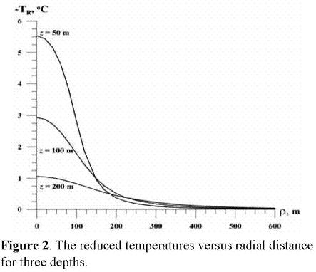
Let's consider a 30 m deep lake with a radius of Ri = 100 m and Tis =10 oC. The regional geothermal gradient is T = 0.0300 oC/m and Tot = 20 oC. The drilling site of a 3000m wellbore is located at a distance of 150m from the center of the lake (Table 1).

What are the magnitudes of the formation temperature perturbations (expressed through the reduced temperatures) caused by the lake? The results of calculations after eqs. (4) and (8) are presented in Table 1 andFigure 2. We have to note that bottom of the lake has a coordinate z = 0 and because of this the actual depth isz* = z + 30m In our case Tis - Tot = -10 oC and the lake has a cooling effect on the temperature profiles. The values of TR(ρ, z) are decreasing with depth and practically can be neglected for radial distances of 550-600 m from the center of the lake (Figure 2).
Let's now assume that we have to determine the maximum values of TR(ρ, z) and AΓ(ρ, z) for the 300-500 m section of the wellbore. The values of TR(ρ, z) can be estimated directly from eq. (13) and
Table 1:
Tr(150,300)= -10°C•0.0384 = -0.384 oC;
Tr(150,500)= -10oC•0.0172 = -0.172 oC
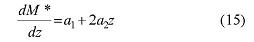
To determine the values of AΓ (ρ, z) for this case we suggest to approximate the function M by a quadratic polynomial (Table 2, eq. (14)).

a0 = 0.1126 a1 = -0.3341•10-3 a2 = 0.2872 • 10-6
Then the values of ΔΓ(ρ, z) can be determined from eqs. (12) and (15):
ΔΓ(150,300) = 1,6174•10-3 oC/m;
ΔΓ(150,500) = 0.4684•10-3 oC/m
For the 300-500m section of the well the values of TR(ρ, z) and ΔΓ(ρ, z) are presented in Figure 3. In our example the value of the regional geothermal gradient (r) is 0.03 °C/m. Thus, the accuracy of the determined geothermal gradient is somewhere between
(0.4684-10-3/0.03)•100% = 1.56% and
(1.6174-10-3/0.03) )•100% = 5.39%


At the same time for a wellbore located at the center of the lake the values TR and ΔΓ are maximal (Table 1, eqs. (12) and (13)):
TR(0,300) = -10°C-0.0513 = -0.513 °C;
TR(0,500)= -10oC-0.01942 = -0.194 °C,
ΔΓ(0,300) = 3.16•10-3 °C/m
ΔΓ(0,500) = 0.754•10-3 °C/m
A commercially available software, Maple 7 (Waterloo Maple, 2001), was utilized to compute the function M(ρ, z).
VI. Conclusions
It is shown that borehole paleoclimate investigations are complicated by many disturbing factors, exact calculation of which is a complex physical-mathematical problem. Proposed method allows to estimate the maximum effect of deep lakes on the borehole temperature profiles observed within and outside of the lakes. Authors assumed that the lake existed for an infinitely long period of time. In this case the solution of Laplace equation with nonuniform boundary conditions can be used to describe the steady temperature field ofgeological formations beneath the lakes and estimate the maximum effect (due to assumption that the lake existed for an infinitely long period of time) of lakes on the borehole temperature profiles. A numerical example to estimate the effect was explained in detail. Presented example of calculations testifies to what extent the proximity of a deep lake affects the borehole temperature profiles. An accuracy of the determination of the geothermal gradient is also estimated.
Acknowledgement
The authors thank two anonymous reviewers and Prof. Luis A. Montes V, Editor-in-Chief of the Earth Sciences Research Journal, for their useful comments and suggestions.
References
Abramowitz, M., and I. Stegun (1965). Handbook of Mathematical Functions, Dover Publications Inc., N. Y.
Allen, M. R., N. P. Gillett, J. A. Kettleborough, G. Hegerl, R. Schnur, P.A. Stott, G. Boer, C. Covey, T. L. Delworth, G. S. Jones, J. F. B. Mitchell, and T. P. Barnett (2006). Quantifying anthropogenic influence on recent near-surface temperature change, Survey of Geophysics, 27, 491-544.
Balobaev, V. T., I. M. Kutasov, andL. V. Eppelbaum (2008). Borehole paleoclimatology - the effect of deep lakes and "heat islands" on temperature profiles, Climate of the Past, No.4, 1-18.
Balobayev, V. T., and Yu. G. Shastkevich (1974). The estimation of the talik zones configuration and the steady temperature field of rocks beneath the lakes of arbitrary contour, In: Lakes of the Siberia Cryolithozone (in Russian), Nauka Publ., Novosibirsk, 116-127.
Beltrami, H., A. M. Jessop, and J.- C. Mareschal (1992). Ground temperature histories in eastern and central Canada from geothermal measurements: Evidence of climate change, Palaeo-geogr. Palaeoclimatol. Palaeoecol .(Global Planet. Change Sect.), 98, 167-183.
Blackwell, D. D., J. L. Steele, and C.A. Brott (1980). The terrain effect on terrestrial heat flow, Journal of Geophysical Research, 85(B9), 4757-4772.
Bodri, L., and V. Cermak (1995). Climate change of the last millennium from borehole temperatures: results from the Czech Republic - Part I, Global Planetary Change, 11, 111-125.
Bodri, L., and V. Cermak, (2005). Borehole temperatures, climate change and the pre-observational surface air temperature mean: Allowance for hydraulic conditions, Global Planetary Change, 45, 265-276.
Carslaw, H. S., and J. C. Jaeger (1959). Conduction of Heat in Solids, Oxford University Press, N. Y.
Cermak, V., and L. Bodri (2001). Climate reconstruction from subsurface temperatures demonstrated on example of Cuba, Physics of the Earth and Planetary Interiors, 126, 295-310.
Chouinard, C., and J.- C. Mareschal (2007). Selection of borehole temperature depth profiles for regional climate reconstructions, Climate of the Past, 3,297-313.
Covington, W. W. (1981). Changes in the forest floor organic matter and nutrient content following clear cutting in northern hardwoods, Ecology, 62, 41-48.
Eppelbaum, L. V., I. M. Kutasov, and G. Barak (2006). Ground surface temperatures histories inferred from 15 boreholes temperature profiles: comparison of two approaches, Earth Sciences Research Journal, 10, No. 1, 25-34.
Gonzalez-Rouco, J. F., H. Beltrami, E. Zorita, and M. B. Stevens (2008). Borehole climatology: a discussion based on contributions from climate modeling, Climate of the Past Discussions, 4, 1-80.
Gruber, S., L. King, T. Kohl, T. Herz, W. Haeberli, and M. Hoelzle (2004). Interpretation of geo-thermal profiles perturbed by topography: the Alpine permafrost boreholes at Stockohorn plateau, Switzerland, Permafrost and Periglacial Processes, 15, 349-357.
Gosselin, C., and J.- C. Mareschal, (2003). Variations in ground surface temperature histories in the Thompson Belt, Manitoba, Canada: environment and climate changes, Global and Planetary Change, 39, 271-284.
Guillou-Frottier, L., J.- C. Mareschal, and J. Musset (1998). Ground surface temperature history in central Canada inferred from 10 selected borehole temperature profiles, Journal of Geophysical Research, 103, No. B4, 7385-7397.
Hamza, V.M., A. S. B. Cavalcanti, and L. C. C. Benyosef (2007). Surface thermal perturbations of the recent past at low latitudes - inferences based on borehole temperature data from Eastern Brazil, Climate of the Past, 3, 513-526.
Harris, R. N., and S. D. Chapman (1995). Climate change on the Colorado Plateau of eastern Utah inferred from borehole temperatures, Journal of Geophysical Research, 100, 6367-6381.
Hopcroft, P.O., K. Gallagher, and C.C. Pain (2007). Inference of past climate from borehole temperature data using Bayesian Reversible Jump Markov chain Monte Carlo, Geophysical Journal Intern., 171, 1430-1439.
Huang, S., P. Y. Shen, and H. N. Pollack (1996). Deriving century - long trends of surface temperature change from borehole temperatures, Geophysical Research Letters, 23, 257-260.
Huang, S., H. N. Pollack, and P. Y. Shen (2000). Temperature trends over past five centuries reconstructed from borehole temperatures, Nature, 403, 756-758.
Huang, S., and H. N. Pollack (1998). Global Borehole Temperature Database for Climate Reconstruction, IGBP PAGES/World Data Center-A for Paleoclimatology Data Contribution Series #1998-044.NOAA/NGDCPaleoclimatology Program, Boulder CO, USA (see alsohttp://www.geo.lsa.umich.edu/~climate).
Kappelmeyer, O., andR. Haenel (1974). Geothermic with Special Reference to Application, Gebruder Borntrager, Berlin.
Kohl, T. (1999). Transient thermal effects below complex topographies, Tectonophysics, 306(3-4), 311-324.
Kooi, H. (2008). Spatial variability in subsurface warming over the last three decades; insight from repeated borehole temperature measurements in The Netherlands, Earth and Planetary Science Letters, 270, 86-94.
Lachenbruch, A.H. (1965). Rapid Estimation of the Topographic Disturbance to Superficial Thermal Gradients,Review of Geophysics, 6, 365-400.
Lachenbruch, A. H., and B. V. Marshall (1986). Changing climate: Geothermal evidence from permafrost in the Alaskan Arctic, Science, 234, 689-696.
Lewis, T. J., and K. Wang (1998). Geothermal evidence for deforestation induced warming: implications for the climatic impact of land development, Geophysical Research Letters, 25, 535-538.
Majorowicz, J. A., and W. P. Skinner (1997). Potential causes of differences between ground and surface air temperature warming across different ecozones in Alberta, Canada, Global Planetary Change, 15, 79-91.
Majorowicz, J., and J. Safanda (2005) Measured versus simulated transients of temperature logs - a test of borehole climatology, Journal of Geophysics and Engineering, 2, 291-298.
Mottaghy, D., R. Schellschmidt, Y.A. Popov, C. Clauser, I. T. Kukkonen, G. Nover, S. Milanovsky, and R. A. Romushkevich (2005). New heat flow data from immediate vicinity of the Kola super-deep borehole: Vertical variation in heat flow confirmed and attributed to advection, Tectonophysics, 401, 119-142.
Nitoiu, D., and H. Beltrami (2005). Subsurface thermal effects of land use changes, Journal of Geophysical Research, 110, F01005.
Pollack, H. N., and S. Huang (2000). Climate reconstruction from subsurface temperatures, Annual Review of Earth Planetary Sciences, 28, 339-365.
Rath, V., andD. Mottaghy (2007). Smooth inversion for ground surface temperature histories: estimating the optimum regularization parameter by generalized cross-validation, Geophysical Journal Intern., 171, 1440-1448.
Safanda, J. (1994). Effects of topography and climatic changes on the temperature in borehole GFU-1, Prague,Tectonophysics, 239, 187-197.
Safanda, J. (1999). Ground surface temperature as a function of slope angle and slope orientation and its effect on the subsurface temperature field, Tectonophysics, 306(3-4), 367-376.
Safanda, J., D. Rajver, A. Correia, and P. Dedecek (2007). Repeated temperature logs from Czech, Slovenian and Portuguese borehole climate observatories, Climate ofthe Past, 3, 453-462.
Shen, P. Y., K. Wang, H. Beltrami, and J.- C. Mareschal (1992). A comparative study of inverse methods for estimating climatic history from borehole temperature data, Global Planetary Change, 98, 113-127.
Taniguchi, M. (2006). Anthropogenic effects on subsurface temperature in Bangkok, Climate of the Past Discussions, 2, 832-846.
Waterloo Maple (2001). Maple 7 Learning Guide, Waterloo Maple Inc., Waterloo, Canada.
How to Cite
APA
ACM
ACS
ABNT
Chicago
Harvard
IEEE
MLA
Turabian
Vancouver
Download Citation
Article abstract page views
Downloads
License
Earth Sciences Research Journal holds a Creative Commons Attribution license.
You are free to:
Share — copy and redistribute the material in any medium or format
Adapt — remix, transform, and build upon the material for any purpose, even commercially.
The licensor cannot revoke these freedoms as long as you follow the license terms.
The Earth Sciences Research Journal is the copyright holder for these license attributes.


